What Happened
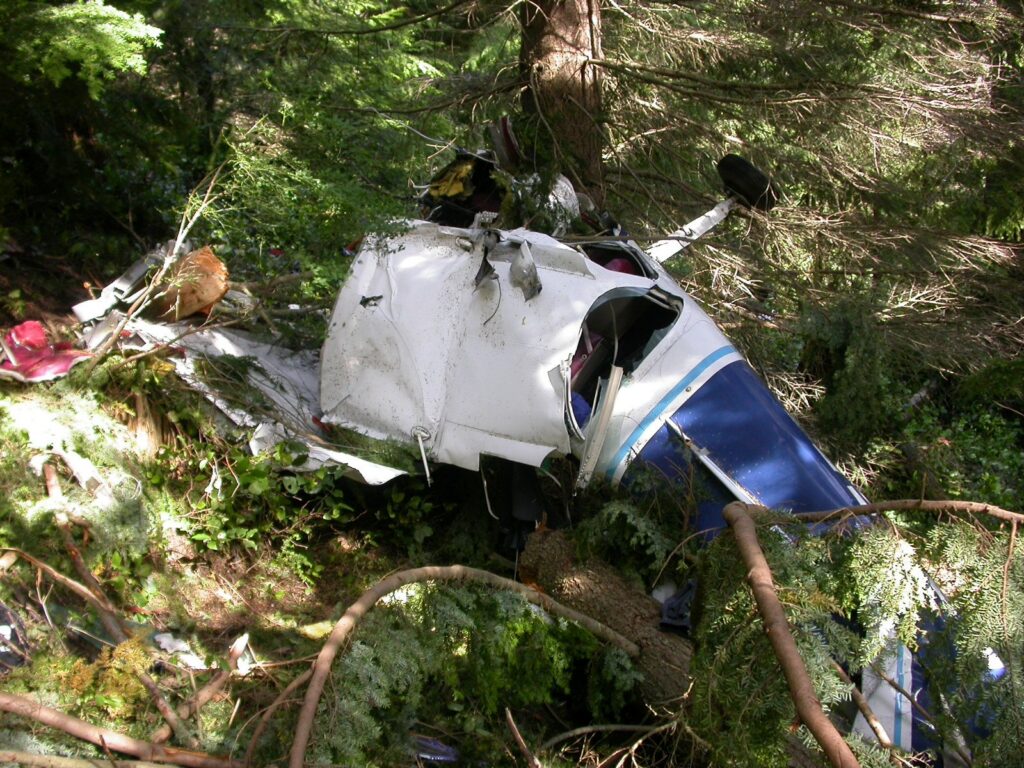
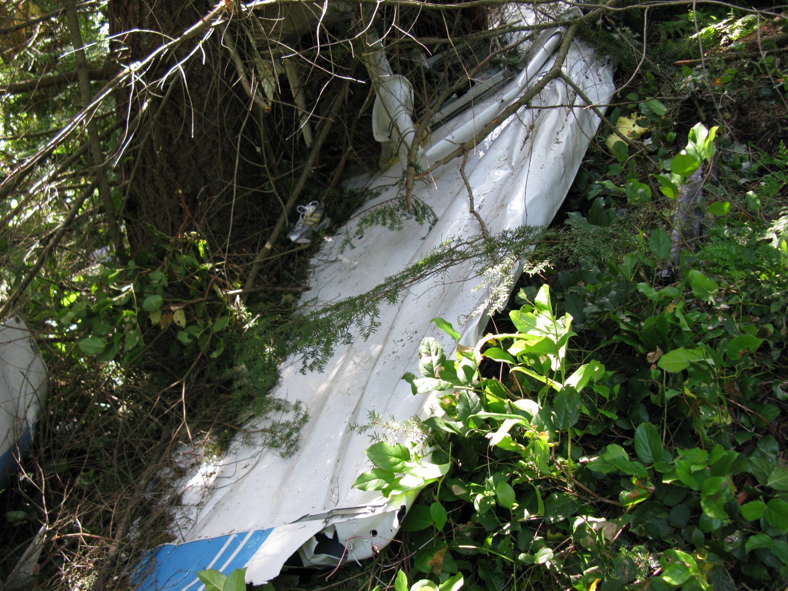
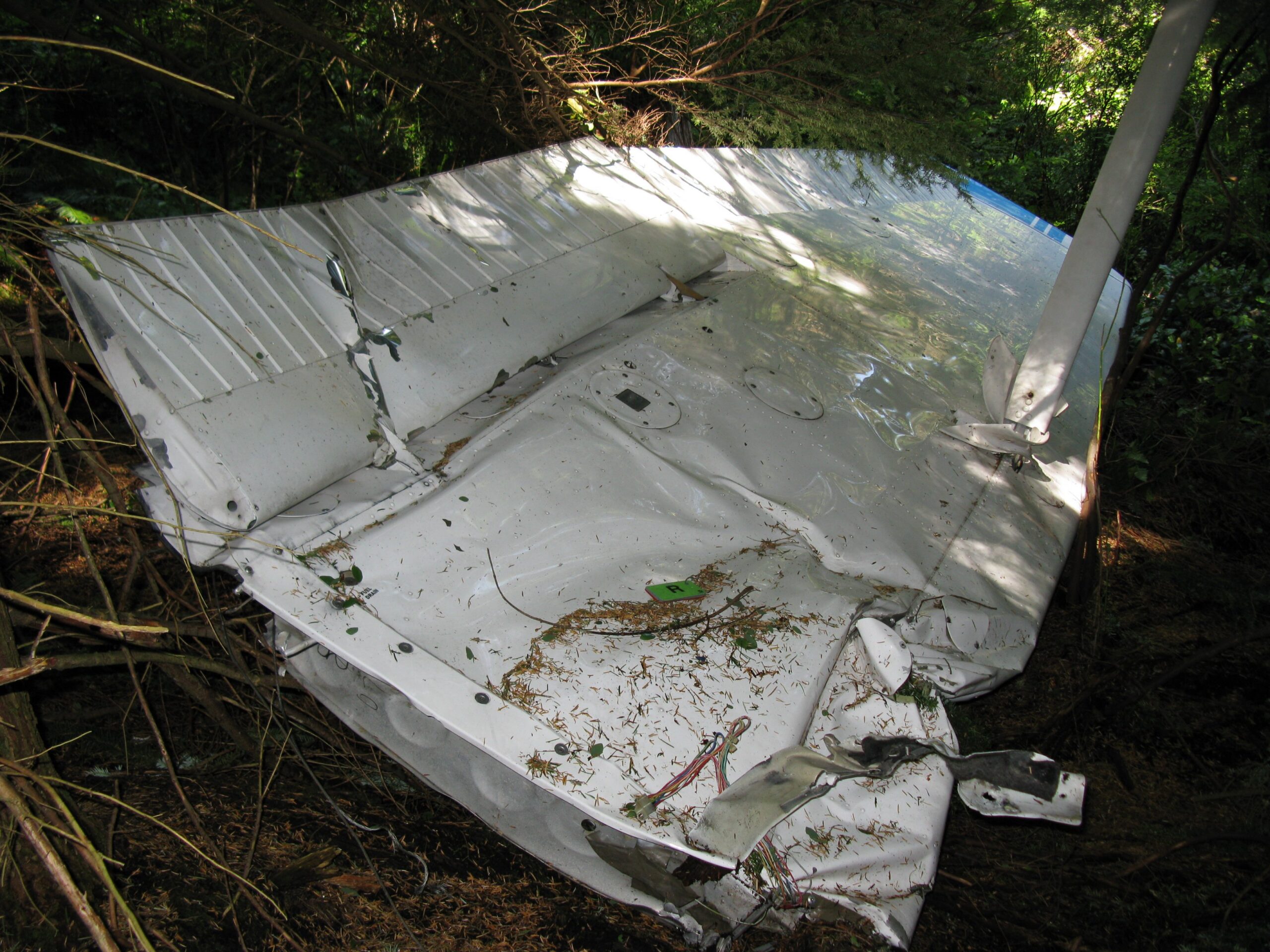
On July 27, 2008, a Cessna 172N, N75558, departed Roche Harbor Airport (WA09) on San Juan Island at approximately 1402 Pacific daylight time, bound for Auburn, Washington. The pilot, a 47-year-old woman holding an airline transport pilot certificate with 14,200 total logged hours, had two passengers aboard. By 1439, the airplane had impacted trees and mountainous terrain at 2,214 feet mean sea level in a heavily wooded area near McMurray, Washington, roughly 6 miles east of town. All three occupants were killed. A family member reported the airplane missing to the FAA that same afternoon after it failed to arrive at its destination. Air search units located the wreckage around 2120 that evening.
The plan for the day was ambitious. The pilot intended to fly from Roche Harbor to Auburn to drop off two passengers, pick up one passenger, return to WA09 to pick up two more passengers, and then make a final leg back to Auburn. It was a shuttle run, the kind of trip that creates subtle pressure to keep moving even when conditions push back. The weather at departure was visual meteorological conditions. What lay to the south was a different story.
About four minutes after takeoff, radar picked up the airplane at 2,200 feet msl, roughly 5 miles southeast of Roche Harbor, tracking southeast toward Auburn. The flight climbed to between 2,400 and 2,500 feet and held that altitude for the next 16 minutes. At 1408, the pilot contacted Whidbey Approach Control and began receiving radar flight following. Two minutes later, at 1410, the controller passed along a piece of information that deserves to sit with you for a moment: he told the pilot that nobody had gone south of Bush Point VFR in the last hour. The pilot’s response was that it looked pretty good so far. She was still north of the deteriorating weather, looking ahead into it, and the view from where she was had not yet turned ugly.
At 1413, the controller instructed the pilot to maintain VFR at or above 2,500 feet msl due to other traffic. At 1419, while talking to a different aircraft in the area, the controller described the weather around Seattle extending 15 to 20 miles north as having pretty limited visibility and low ceilings. He then asked the pilot of N75558 if she had copied that transmission. She acknowledged. And then she told the controller she was going to descend to 2,000 feet. The controller’s reply was essentially a handoff of responsibility: maintain VFR at your discretion. At 1423, radar service was terminated. The controller told her to squawk VFR and frequency change was approved. She acknowledged. Those were the last radio transmissions received from the airplane.
The radar data tells the rest of the story without any words at all. At 1420, while still on a southeasterly heading, the airplane had descended from 2,500 feet down to 900 feet msl. That descent happened over open water and low terrain, where there was room to come down. But 900 feet msl in that area, under a broken ceiling at 500 feet above the surface and an overcast at 2,700 feet, meant the airplane was threading a layer. At 1427, a slight climb began. At 1429, the flight reached the vicinity of Arlington Airport. And then, instead of continuing southeast toward Auburn, the radar track shows a climbing left turn, a full 180 degrees, to a northwesterly heading. Away from the destination. Back the direction she had come from.
Two minutes after that reversal, at 1431, the airplane turned right to a northerly course and continued climbing. Then, from 1434 onward, the radar paints a picture that is hard to look at: a series of left and right turns with altitude fluctuating between 1,500 and 2,900 feet. The airplane was maneuvering. The last three radar returns were consistent with a descending right-hand turn. The final return came at 1439, 0.17 miles southwest of the accident site, at 2,200 feet msl. The airplane impacted trees at essentially that altitude, on an easterly heading, at 085 degrees magnetic. The wreckage energy path ran 175 feet through the woods.
A witness flying a Cessna 170 that afternoon had herself turned back from the same route. She had been planning to fly from Blakely Island to Auburn and elected to return to Blakely because of lowering ceilings and decreasing visibility south of Port Townsend. While working with Whidbey Approach on the return, she was advised of opposite-direction traffic. She observed a Cessna matching the description of N75558 passing in front of her on an eastbound heading. She described the visibility to the east at that moment as very poor.
Investigation Findings
The weather picture assembled by investigators was unambiguous. The National Weather Service Weather Depiction Chart for 1200 that day depicted IFR conditions over Washington in the vicinity of the accident site, with MVFR conditions surrounding it across western Washington and Oregon. The closest VFR conditions were over eastern Washington, across the Cascades from where the airplane was flying. At 1435, four minutes before the final radar return, the automated weather station at Arlington Municipal Airport, about 11 miles southwest of the accident site, was reporting scattered clouds at 500 feet agl, a broken layer at 2,000 feet agl, and an overcast ceiling at 2,700 feet agl, with visibility 10 miles. A Skagit County Sheriff’s deputy positioned just north of the accident site described spotty rain showers and a typical marine layer around the time of impact. The NTSB’s meteorologist confirmed overcast clouds with bases at 1,900 feet agl and tops near 10,000 feet in the immediate vicinity, along with restricted visibility in rain showers. The accident site itself sits at 2,214 feet msl, which means the airplane flew into terrain that was above the cloud base.
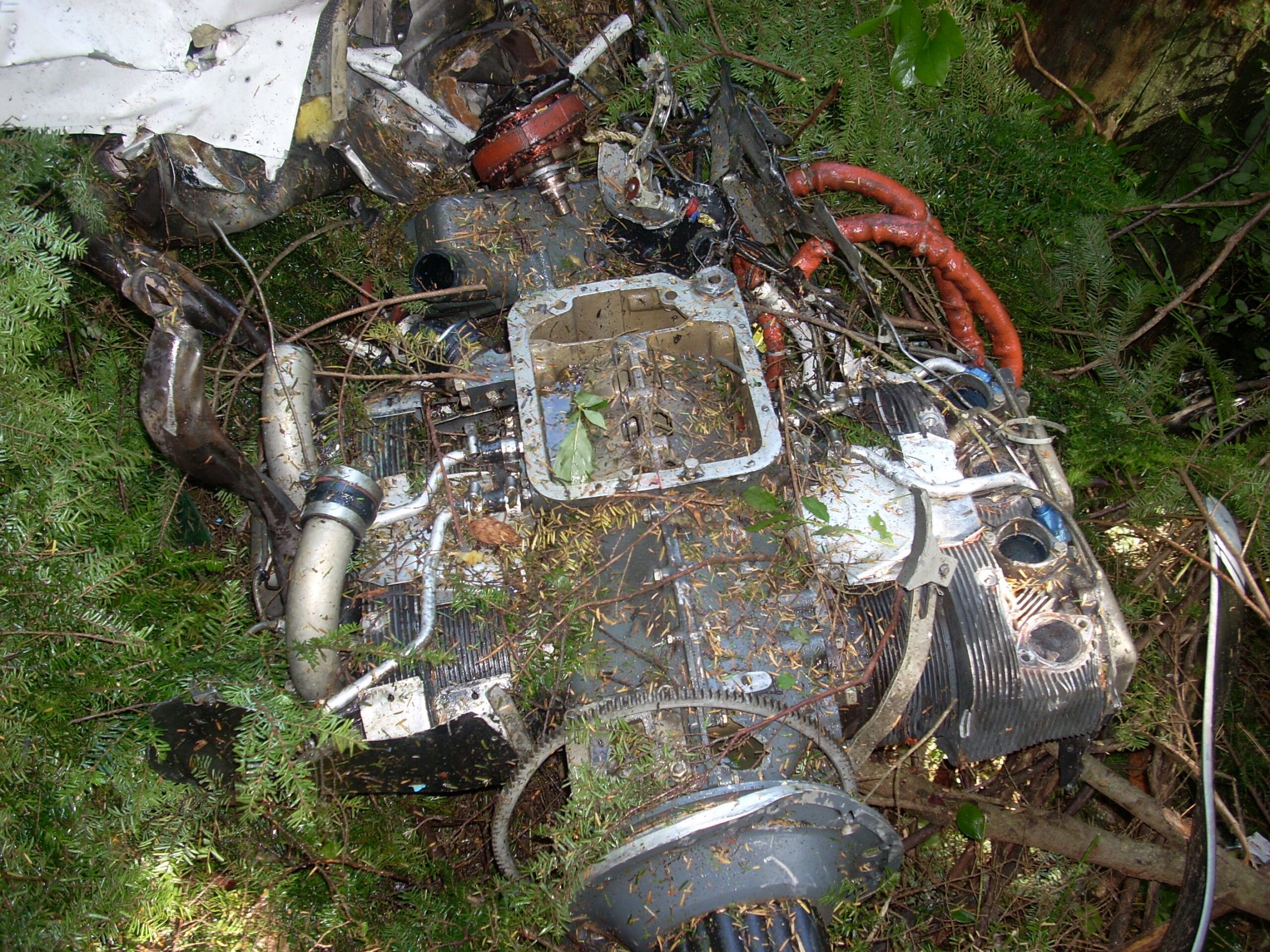
The airframe examination found no mechanical anomalies that would have precluded normal operation. Flight control continuity was confirmed throughout to all primary controls. The engine examination told a more complicated story, though not one that changed the outcome. The number four cylinder’s exhaust valve was found stuck in the open position with a bent stem. The exhaust valve guide was loose in its bore. The camshaft lobes showed severe wear and spalling across all four. The corresponding tappets showed the same signatures. One of the connecting rods had spalling on its bearing surfaces. The Lycoming investigator’s assessment was that the engine exhibited internal wear characteristics consistent with a high-time engine. None of these findings were flagged as the cause of the accident because the wreckage and impact signatures showed the airplane was flying under power when it struck the trees. The bent propeller blades with aft curl are consistent with a rotating, power-producing propeller at impact.
The engine’s maintenance history was worth noting. The number four cylinder had been replaced in August 2007 using a cylinder pulled from a different engine, an O-360-H2AD. Records from that donor engine showed metal had been found in the oil filter and oil suction screen in 2005. The engine as a whole was at 2,559.8 hours since major overhaul against a recommended TBO of 2,000 hours, with no extension documented under the criteria that would allow up to 2,200 hours for high-frequency operations. The carburetor float showed a blue stain and the right pontoon was completely filled with what appeared to be 100LL aviation fuel, suggesting a float that had been compromised and was not seating properly. None of these mechanical issues, individually or collectively, were found to have caused or contributed to the loss of the airplane. The pilot held a first-class medical and there were no toxicological findings of concern. The cause of death for all three occupants was blunt trauma.
One other data point from the pilot’s logbook is worth holding onto. She held an ATP with multiengine and type ratings in transport-category jets. She had 14,200 total hours. But her rental records at Crest Airpark showed she had flown a Cessna 172 on seven occasions over the previous 13 months, for a total of 12.3 hours. In the 90 days before the accident, she had flown 2.5 hours in 172s. A highly experienced pilot by any measure, but not a pilot who had been living in this particular airplane, in this particular type of flying, in this particular airspace.
NTSB Probable Cause
The pilot’s improper decision to continue VFR flight into instrument meteorological weather conditions. Contributing to the accident were low ceilings, reduced visibility, and mountainous terrain.
Safety Lessons
Three people flew into the Washington mountains that afternoon and did not come back. The pilot had more flight experience than almost anyone reading this. The weather information was available. The controller gave her the picture more than once. The airplane worked. What follows isn’t about what she should have known. It’s about the specific, identifiable moments where the decision chain could have broken in a different direction.
- A controller’s advisory is a data point, not a clearance. When Whidbey Approach told the pilot at 1410 that nobody had gone south of Bush Point VFR in the last hour, that was a direct report from the ground picture. The response, that it looked pretty good so far, was honest but it was also a look-ahead bias at work. The conditions ahead were not visible yet. By the time conditions are visible from the cockpit of a slow aircraft in a marine layer, the options narrow quickly. A no-go decision made at WA09, before departure, costs a flight. A no-go decision made at 1,500 feet in deteriorating visibility over mountainous terrain costs far more.
- Total hours and recent hours are different currencies. Fourteen thousand hours in transport-category jets does not transfer directly to VFR judgment in a single-engine 172 operating in the Pacific Northwest marine layer. The instrument scan, the power management, the sight picture, the sense of how fast a C172 descends through a cloud base versus how fast a regional jet does, these things require currency in type and environment. The pilot had 2.5 hours in 172s in the previous 90 days. High total time is a genuine asset. But it can also create confidence that outruns the specific skill set the current flight demands.
- Mountainous terrain resets the math on altitude margins. Cruising at 2,500 feet msl sounds comfortable until the terrain is also at 2,200 feet. The accident site was at 2,214 feet. The radar track shows the airplane maneuvering with altitude fluctuating between 1,500 and 2,900 feet in an area where the terrain reaches up to meet the clouds. A VFR cloud clearance requirement of 500 feet below clouds means very little when the clouds and the terrain meet at the same elevation. In mountainous IFR conditions, the margin between legal and fatal can measure in tens of feet.
Frequently Asked Questions
Q: What does “VFR into IMC” mean and why is it so dangerous?
A: VFR into IMC means a pilot flying under Visual Flight Rules enters Instrument Meteorological Conditions, essentially flying into clouds or visibility so low that outside visual reference is lost. Without instrument training and proficiency, spatial disorientation typically develops within minutes. The inner ear cannot distinguish straight-and-level flight from a gradual turn or descent, and the pilot often enters an accelerating spiral without realizing it. In mountainous terrain, there may be no altitude available to recover even if the pilot recognizes the situation.
Q: The pilot had an ATP certificate and 14,200 hours. How does CFIT still happen to highly experienced pilots?
A: Experience in one environment does not automatically transfer to another. This pilot’s hours were accumulated primarily in multiengine and jet transport aircraft, which operate under IFR procedures with full crew and sophisticated avionics. Flying a rented Cessna 172 VFR through a Pacific Northwest marine layer at low altitude over mountainous terrain is a fundamentally different operating environment. Additionally, high total time can create a confidence level that is not calibrated to the specific risks of the current flight. The NTSB found she had only 2.5 hours in Cessna 172s in the 90 days before the accident.
Q: Did the ATC controller do anything wrong by terminating radar service?
A: The NTSB did not cite ATC as a contributing factor. The controller provided multiple weather advisories, including explicitly telling the pilot no aircraft had proceeded south VFR in the preceding hour and later relaying a weather description of limited visibility and low ceilings. Radar service on a VFR flight following basis is a workload-permitting service, and the controller terminated it appropriately. Responsibility for maintaining VFR and for the go/no-go decision rested with the pilot in command.
Q: What did the engine anomalies found during investigation mean for the flight?
A: The bent exhaust valve, camshaft wear, and other internal findings were consistent with a high-time engine that had accumulated 2,559.8 hours against a recommended TBO of 2,000 hours. However, the NTSB determined these anomalies did not cause or contribute to the accident. The propeller damage was consistent with the engine producing power at impact, and wreckage signatures showed the airplane was under control when it struck the terrain. The cause was navigational, not mechanical.
Q: What is a marine layer and why does it create such a specific hazard for Pacific Northwest VFR pilots?
A: A marine layer is a shallow, stable mass of moist air that flows inland off the Pacific Ocean, typically producing low ceilings, fog, and reduced visibility beneath an overcast deck. In western Washington, it frequently sits at 1,000 to 2,500 feet msl, which places cloud bases at or below the tops of the foothills and lower Cascade ridges. A pilot flying at 2,500 feet under a marine layer overcast can find themselves in a narrowing corridor where the clouds descend to meet the terrain, leaving no altitude to descend below the clouds and no ceiling above which to climb VFR. The NTSB’s meteorologist confirmed this was the condition in the accident area on July 27, 2008.