What Happened
On October 10, 2009, sometime around 1300 Pacific daylight time, a 1946 Taylorcraft BC12-D1, registered N44362, lifted off from Harvey Field in Snohomish, Washington. The pilot, a 51-year-old Sport Pilot with an estimated 180 total flight hours and roughly 140 of those in Taylorcrafts, had just finished refueling. Records from the self-serve pump showed he put 12.05 gallons of 100LL into the tanks at approximately 1255. Where he was going, he hadn’t told anyone. No flight plan. No destination. No ELT on board. That last detail would matter enormously in the days ahead.
When he didn’t show up for a family activity planned for 1830 that evening, relatives reported him overdue and missing. The Washington State Department of Transportation Search and Rescue Unit stood up a search that would ultimately last about ten days. Because people who knew the pilot well believed he’d been keeping his flying local, staying in the Snohomish, Arlington, and Darrington area while he broke in a used Continental A65-8 engine recently installed on the airplane, that’s where the search focused initially. They found nothing.
About four days in, a new piece of information surfaced. A man at Westport Airport, roughly 117 statute miles southwest of Snohomish on the Washington coast, came forward and said he believed he had talked with the pilot of N44362 on the afternoon of October 10. He described watching a Taylorcraft land at Westport, and then chatting with its pilot for about 30 minutes after the airplane taxied to parking. The conversation was mostly about homebuilt airplanes. The pilot had introduced himself by name. He mentioned he was going to walk about a mile into town to meet up with the pilot of another airplane already on the ramp. The witness didn’t speak with him again, but he did watch the Taylorcraft take off sometime between 1600 and 1700, heading northwest toward Hoquiam. That was the last known sighting.
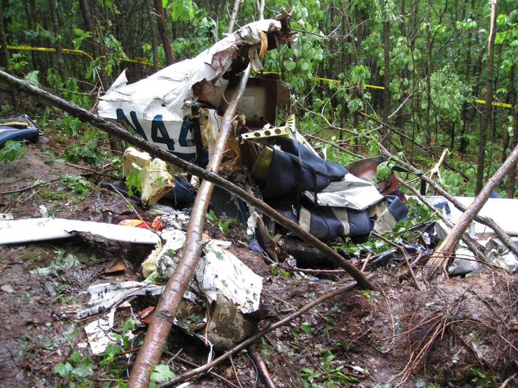
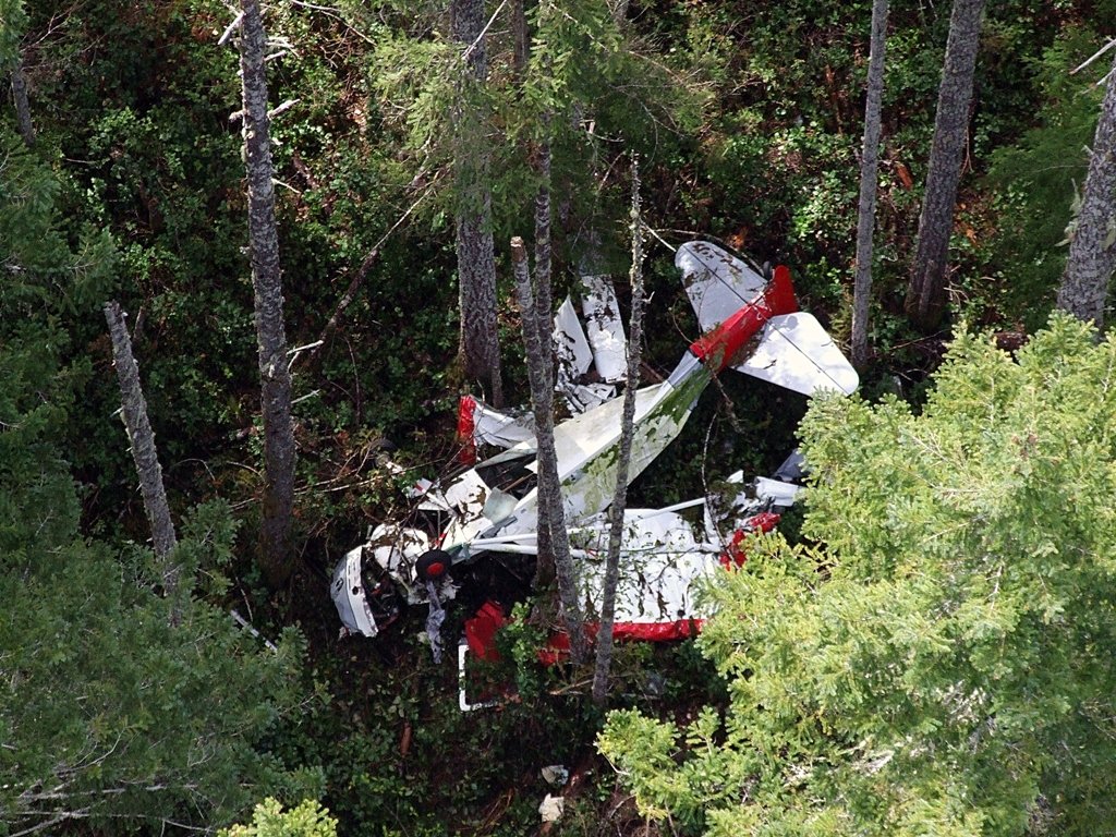
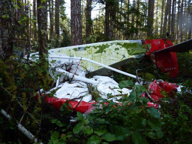
Search and Rescue pulled radar data for the corridor between Harvey Field and Westport, shifted the search area accordingly, and kept looking. They still found nothing, and eventually terminated the effort. Then, on April 30, 2010, almost seven months after the flight, two people picking Salal on the densely forested lands of the Skokomish Tribal Reservation walked into a small clearing in the trees and found the wreckage. The accident site was located about 1.3 miles northwest of Skokomish, Washington, near the top of a nearly flat north-south running ridge. The altitude of that ridgetop was 560 feet above sea level. The remains of the pilot were found with the airplane. Death was later determined to have resulted from multiple blunt force injuries to the torso and right lower extremity.
The crash site sat about 1.5 miles southeast of the direct line between Westport and Snohomish. If the witness account was accurate, the pilot had departed Westport somewhere between 1600 and 1700, heading home. Official sunset that day was 1830. He was somewhere between halfway and two-thirds of the way home when the left wing of his Taylorcraft clipped the tops of two 80-foot conifers on a ridge he apparently never saw coming.
Investigation Findings
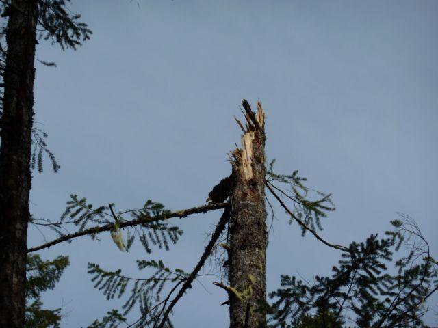
When investigators reached the wreckage site, the picture it painted was one of controlled flight directly into terrain, specifically into the forest canopy on top of that ridge. The outboard four feet of the left wing were found about 115 feet south of the main wreckage, near two tall conifers that had been broken off near their tops. Eight additional trees of smaller diameter had been snapped off at various heights along the path from the separated wingtip section to where the fuselage came to rest. Two of those trees, each about eight inches in diameter, had been cleanly severed. The cuts were smooth and straight, with silver-gray discoloration on the cut faces consistent with contact from a spinning metal propeller. One of those severed trunks was found roughly halfway between the initial tree strike and the main wreckage. The other was about ten feet further down-track. The engine was running when this airplane entered the trees.
The propeller confirmed it. Both blades were still attached to the crankshaft, and neither had buried itself into the soft ground in a way consistent with a stationary prop at impact. More telling were the blade tips. One showed burnishing of its paint extending between a quarter and a half inch aft of the leading edge, with the tip bent back sharply at about 40 degrees. The other tip was folded back about 45 degrees inboard, then curved forward nearly 180 degrees, with the outermost two inches bent sharply aft again, and the black paint and chromate primer burnished all the way through to bare aluminum across more than two inches aft of the leading edge. That pattern of tip deformation and surface burnishing is consistent with a propeller that was rotating at significant speed when it struck solid objects. A stationary or windmilling propeller doesn’t leave that kind of evidence.
The engine teardown confirmed no pre-existing mechanical problem. The IIC pulled all four cylinders, removed the pistons, inspected the crankshaft, camshaft, and connecting rods, checked the oil filter screen, disassembled the carburetor, and rotated both magnetos by hand. The left magneto failed to produce spark during initial testing, but follow-on inspection at a magneto shop in Bainbridge Island found only oxidation on the points, consistent with seven months of exposure to Pacific Northwest rain. After cleaning the points, the magneto produced strong spark across all leads through the full rpm range. There was no mechanical reason this airplane couldn’t have been producing full rated horsepower from its 65-horsepower Continental right up to the moment it hit those trees.
The fuselage itself told an interesting story too. It came to rest inverted in the underbrush, with both wings folded almost straight back along the fuselage sides from the force of hitting multiple trees. But the fuselage structure, apart from some bending across the top of the cabin and a roughly 20-degree bend in the longerons just ahead of the tail, was largely intact. Rudder, elevator, and elevator trim continuity checked out from cockpit to control surfaces. The throttle was sitting about an inch and a half short of full power. The ignition key was in the left magneto position and was bent about 45 degrees to the right. The airplane had been flying, under power, at low altitude over hilly forested terrain when it met those trees.
The timing matters here. The witness at Westport saw the Taylorcraft depart between 1600 and 1700. Sunset was at 1830. A Taylorcraft BC12-D1 with a Continental A65-8 and a metal prop cruises between 90 and 95 miles per hour burning roughly 4.5 to 5 gallons per hour. The direct route from Westport back to Snohomish is 117 miles. At those numbers, the flight would take between 1.2 and 1.3 hours. The accident site was just short of the halfway point. That puts the impact somewhere between 1700 and 1830, in the last hour or so before sunset, over ridgeline terrain rising to 560 feet while the pilot navigated by visual reference alone. The airplane had no electrical system, no transponder, no ELT, and no radio that anyone could verify. There was no one to call, and no one tracking where he was.
NTSB Probable Cause
The pilot’s failure to maintain clearance from trees while flying over hilly, forested terrain.
Safety Lessons
Seven months passed before anyone found this airplane. The pilot’s family spent that time not knowing. Search and Rescue spent ten days and significant resources looking in the wrong places. A lot of that traces back to decisions made before the engine even started. There are a few threads worth pulling here.
- Tell someone where you’re going. This pilot told no one his destination. When he didn’t come home, Search and Rescue had almost no information to work with. The initial search focused on the wrong area entirely because the best information available was what people assumed about his flying habits. A simple text message, a note on the counter, a call to Flight Service with an itinerary, any of it would have directed rescuers toward the right corridor from day one. Sport Pilots operating under Part 91 with no flight plan and no ELT are invisible to the system. That’s a choice, and it carries consequences that extend beyond the pilot alone.
- An ELT is not optional for two-seat LSA operations. FAR 91.207 requires an ELT meeting TSO C-91 or C-91a on a two-seat light sport aircraft. This airplane did not have one, which was a regulatory violation, not just an oversight. An activated ELT in that forest would not have saved the pilot, but it would have ended the search in hours instead of months. If you’re operating a two-seat LSA, verify your ELT compliance before every flight, not just at annual.
- Low-altitude cruise over hilly forested terrain demands active terrain awareness. The ridgeline that ended this flight topped out at 560 feet above sea level. That is not a dramatic elevation. But flying at low altitude on a direct course over rolling terrain covered in 80-foot conifers compresses your margin for error to nearly zero. A Taylorcraft cruising at 90 miles per hour is covering 132 feet every second. The two tall trees that separated the left wingtip from the airplane were, at the moment of impact, the only terrain feature that mattered. Flying direct routes over unfamiliar forested terrain in the hour before sunset, at low cruise altitude, removes every buffer the pilot might otherwise have had. Sectional charts show terrain elevation and forested areas. Build in a margin, especially when the sun is getting low and depth perception starts to flatten out.

Frequently Asked Questions
Q: Why did the search take so long and cover the wrong area?
A: The pilot told no one where he was going, filed no flight plan, and the airplane had no ELT. Search and Rescue initially focused on the Snohomish, Arlington, and Darrington area based on what people assumed about his typical flying. The Westport witness account didn’t surface until about four days into the search, and even after redirecting to the Westport-to-Snohomish corridor, the wreckage was never located. The dense coniferous forest on the Skokomish Tribal Reservation simply concealed the airplane completely until Salal pickers stumbled onto it nearly seven months later.
Q: Was the engine running when the Taylorcraft hit the trees?
A: Yes. Two tree trunks along the wreckage path had been cleanly severed with smooth cuts and silver-gray staining consistent with propeller contact. The propeller blade tips showed characteristic burnishing and deformation patterns consistent with rotation at significant speed. A full teardown inspection of the Continental A65-8 engine found no pre-existing mechanical anomalies. The left magneto failed initial testing but passed after cleaning oxidation from the points, oxidation that was attributed to seven months of exposure to the elements. The engine was almost certainly producing power at the moment of impact.
Q: Did the Taylorcraft BC12-D1 require an ELT?
A: Yes. FAR 91.207 requires a two-seat light sport aircraft to carry an ELT meeting TSO C-91 or C-91a. This airplane was being operated as a two-seat LSA and did not have one aboard, which was a violation of federal aviation regulations. The airplane also lacked an electrical system and a transponder, neither of which were required for LSA operations, but the absence of an ELT was a regulatory non-compliance, not merely a missing optional item.
Q: How far was the accident site from the direct route home?
A: The crash site on the Skokomish ridge was about 1.5 miles southeast of the direct line between Westport and Snohomish, Washington. The direct route between those two airports covers 117 statute miles, and the accident site was located just short of the halfway point on that route. Based on departure time estimates from the Westport witness and the 1830 sunset, the impact likely occurred within the last hour or so of daylight.
Q: What were the weather conditions at the time of the accident?
A: Visual meteorological conditions prevailed throughout the region. The 1653 METARs from nearby stations showed visibility at 10 statute miles across the board, with ceilings ranging from scattered at 6,500 feet to overcast at 8,000 feet. Winds were light, temperatures were in the low-to-mid teens Celsius. Weather was not a factor. This was a clear-day CFIT accident on terrain that should have been visible.