What Happened
On the morning of June 22, 2012, a Raytheon C90GT King Air, N508GT, operated by Oz Gas Aviation LLC, struck a communications tower approximately 7.9 nautical miles northeast of Morgantown Municipal Airport (MGW) in Morgantown, West Virginia. The certificated airline transport pilot was fatally injured. The airplane was substantially damaged. The flight had been a short, 19-nautical-mile positioning hop flown under VFR with no flight plan filed.
The day had actually started at another airport entirely. At 0924 that morning, N508GT departed Rigrtona Airport (13PA) near Tidioute, Pennsylvania, carrying the pilot and three passengers bound for Nemacolin Airport (PA88) near Farmington, Pennsylvania. The airplane climbed VFR to 8,000 feet, talked to Cleveland Center, and landed on runway 23 at PA88 at 0944. The pilot parked the airplane, shut down both engines, and put his passengers on a shuttle bus to the Nemacolin Woodlands Resort. He told them he’d be back the following day to pick them up.
That was the last they saw of him. After the passengers walked away, the pilot restarted both PT6A-135A engines, idled for about two minutes, and back-taxied on runway 23. At 0957, he broke ground for what should have been a routine 19-mile ferry flight to Morgantown to refuel and spend the night. He climbed to 3,100 feet msl on a heading aimed directly at MGW. The terrain between PA88 and MGW is not flat. That part of West Virginia sits inside a Designated Mountainous Area, and the quadrangle surrounding the accident site carried a published Maximum Elevation Figure of 3,500 feet on the VFR sectional. The pilot was flying 400 feet below the highest known obstruction in that box.
About nine miles northeast of Morgantown, the pilot contacted Clarksburg Approach Control. The controller issued a discrete squawk code of 0130, acquired radar contact, confirmed the airplane’s altitude at 3,100 feet, told the pilot to maintain VFR, and gave him runway 18 to expect at MGW. The controller also had the tower’s location plotted on his radar map as a known obstruction to flight. At the moment radar contact was established, N508GT was approximately 3.8 nautical miles northeast of the tower and flying at an altitude that put its trajectory below the top of the antenna. The controller said nothing about the tower.
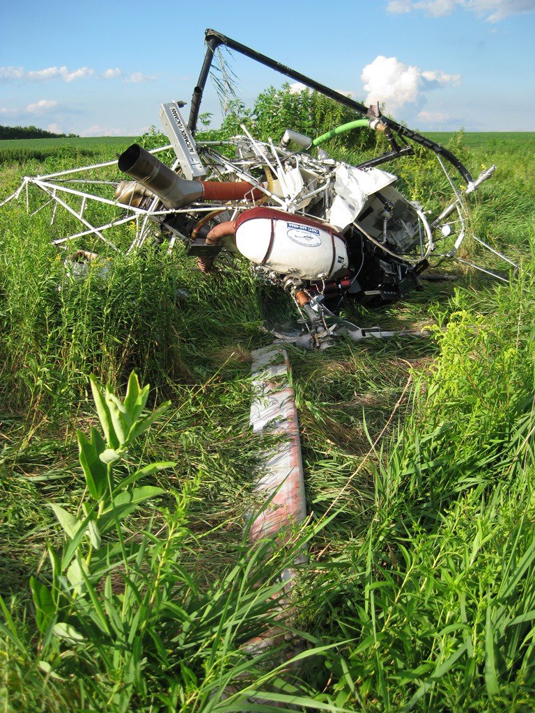
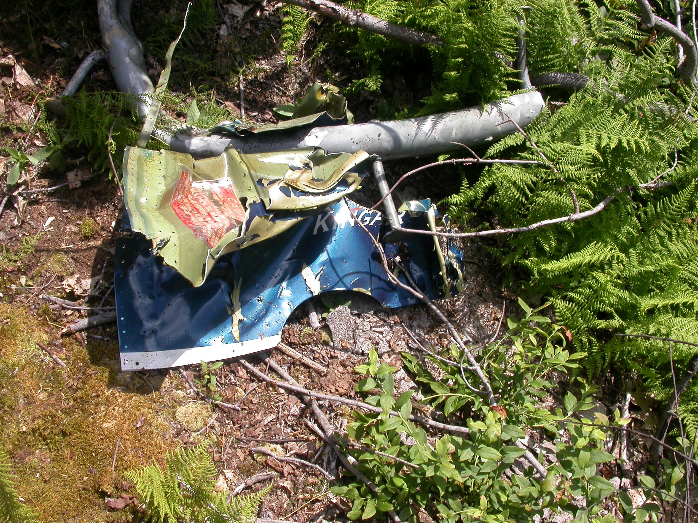
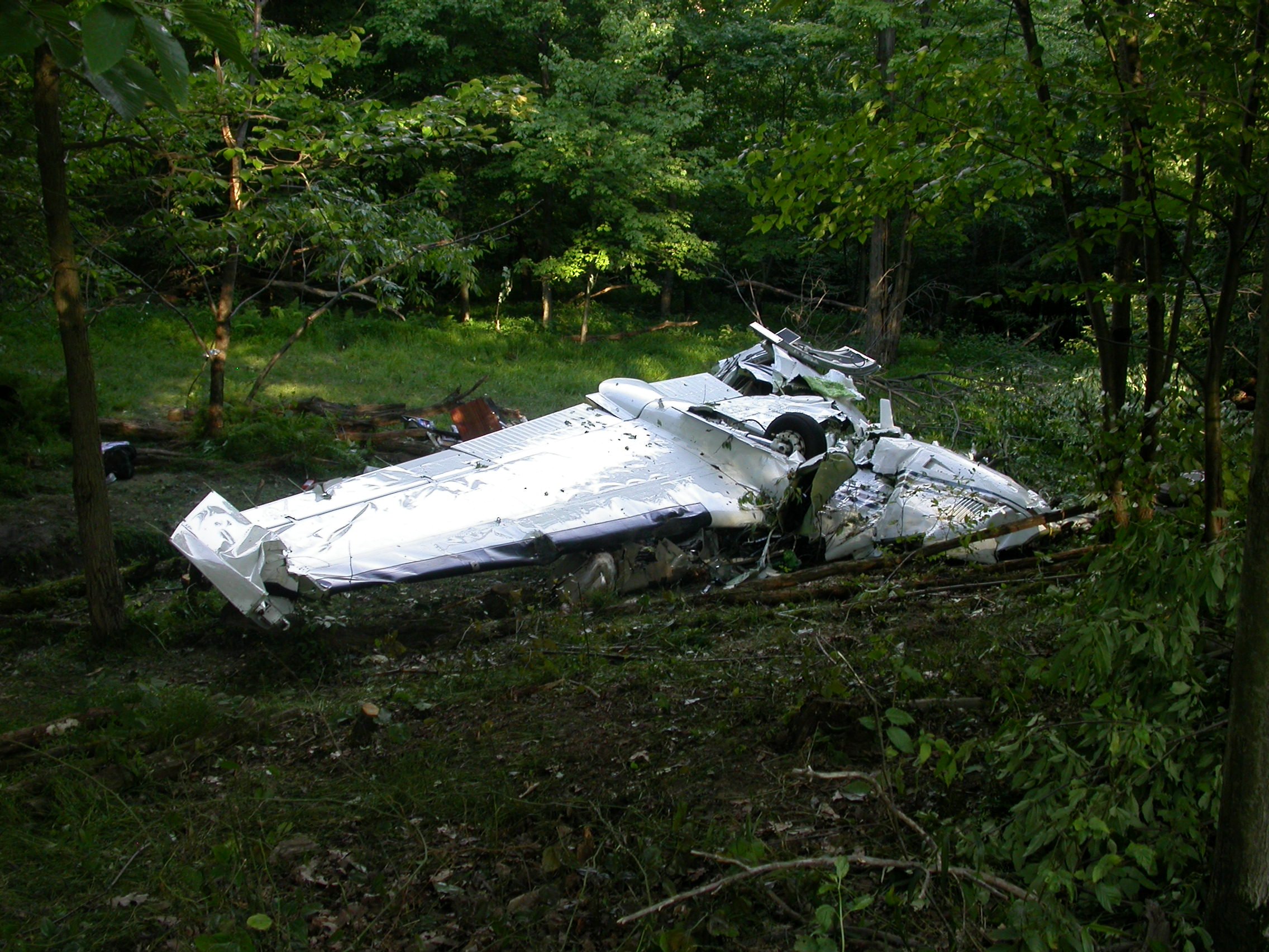
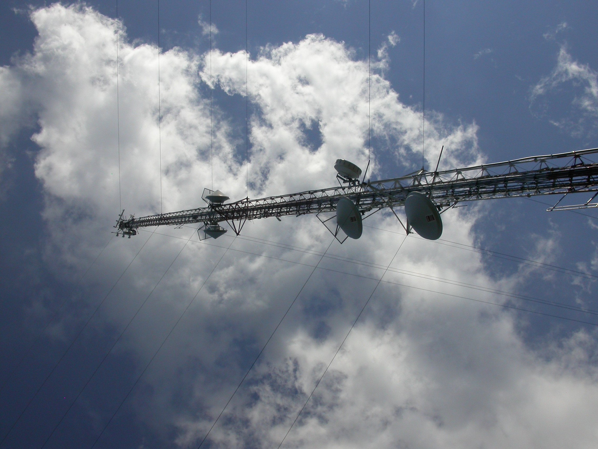
The pilot acknowledged the radar contact call at 1000:28. “Uh roger, we’re getting it,” he said, apparently retrieving the Morgantown automated weather broadcast. The CVR captured the ATIS broadcast starting at 1000:27. It was still playing when the recording ended. At 1001:00, the airplane struck the communications tower’s antenna. The tower’s overall height above mean sea level was approximately 3,089 feet. The airplane had descended to 3,000 feet. The right engine spinner made first contact with the antenna. The right wing broke apart and fragmented. The left horizontal stabilizer separated. The left engine tore free of its mount. The fuselage and left wing came down inverted, 0.3 miles from the tower. Wreckage was spread over a half-mile path on a 244-degree heading. The CVR stopped recording at 1001:01, 33 seconds after the pilot’s last transmission.
A logger working across the road said the weather had been cloudy with lightning and thunder, and it had just started sprinkling when he heard a loud bang. He turned and watched the airplane descend inverted before it impacted the ground. About 20 minutes later, the rain stopped. He noted he could still see the top of the tower while it was sprinkling. The weather at MGW itself, reported at 0953, showed 9 miles visibility with a few clouds at 1,700 feet. But between PA88 and the airport, in the mountainous terrain to the east, satellite imagery and surface observations told a different story. From 0900 to 1100, mid-level cloud cover had been increasing. Cumulus clouds were building at 1,500 to 3,000 feet above ground level, concentrated near the ridgelines. The pilot was not flying into clear air toward a benign destination. He was flying low, fast, through deteriorating conditions, in mountainous terrain, at 217 knots ground speed, with his terrain warning system switched off.
Investigation Findings
Examination of the wreckage revealed no preimpact mechanical failures. The engines produced power until the moment of impact. The flight controls showed no anomalies. Both propellers showed evidence of rotation at impact. This was not a mechanical event. The airplane flew into the tower under its own power, under the control of a pilot who held an airline transport certificate with 22,000 logged hours.
The EGPWS data download told one of the most consequential parts of the story. The airplane was equipped with a Bendix/King KMH880 enhanced ground proximity warning system, which uses GPS, terrain databases, and obstacle databases to alert crews when terrain or obstructions become a threat. There is a terrain inhibit switch on the system. The pilot’s guide is explicit: the switch exists to suppress nuisance warnings at airports not in the database, specifically private strips and runways shorter than 2,000 feet. The guide states in capital letters that the switch should NOT be engaged for normal operations. The EGPWS flight log showed that the terrain inhibit switch was activated 20 seconds before landing at PA88 and was never turned off. The airplane took off from PA88 with terrain warnings silenced. Approximately three minutes after departure, the EGPWS calculated an obstacle alert for terrain. Because the inhibit switch was on, no aural or visual warning reached the pilot. That was the last data stored on the unit. The system saw the danger. The pilot had removed its ability to say anything.
The CVR added a detail that put the terrain inhibit habit into context. During the inbound leg to PA88 earlier that morning, as the airplane descended through 500 feet on approach, a passenger commented that he hadn’t heard any terrain warning. The pilot’s response was that he had turned it off. Review of the EGPWS flight log confirmed that this was a routine practice when flying into 13PA, a private strip not in the system database. The normal pattern, according to the stored data, was to inhibit terrain warnings for the approach and landing, then disengage the switch after departure. On this flight, the switch stayed on. Whether the pilot was distracted, interrupted, or simply forgot, the inhibit remained active for the entire fatal flight. Aeronautical charts found in the wreckage, though approximately two years out of date, depicted the tower. The EGPWS database, also never updated since the unit was installed, still contained the obstacle. The system was ready to warn him. He had disabled it.
The ATC picture was equally stark. When Clarksburg Approach established radar contact at 1000:19, N508GT was 3.8 nautical miles from the tower and closing at roughly 217 knots. That left approximately 62 seconds. The tower was plotted on the controller’s radar map. The airplane’s indicated altitude of 3,100 feet, dropping to 3,000, put it below the tower’s 3,089-foot MSL top. FAA Order 7110.65 assigns safety alerts as the first duty priority for a controller once an unsafe proximity to terrain or obstructions is recognized. Between 1001:05 and 1001:32, the controller was engaged in a conversation with a C-130 conducting a practice approach at Elkins. The airplane struck the tower at 1001:12. The controller made his first unsuccessful attempt to reach N508GT at 1001:37.
The pilot held an ATP with type ratings for the CE-500, DA-10, IA-JET, LR-JET, N-265, and CE-525S, and a flight instructor certificate covering both airplanes and helicopters. His toxicology results were positive for amlodipine, a calcium channel blocker for high blood pressure; pioglitazone, an oral antidiabetic agent for type 2 diabetes; and glucose in the urine. FAA records confirmed a history of coronary artery disease with a stent, type 2 diabetes treated with oral and injectable medications, high blood pressure, and a prior stroke. He held a special issuance second-class medical, valid only through August 31, 2012. The NTSB found no evidence that these conditions contributed directly to the accident. No record of a completed FAA flight review within the two years preceding the accident was found.
NTSB Probable Cause
The pilot’s inadequate preflight route planning and in-flight route and altitude selection, which resulted in an in-flight collision with a communications tower in possible instrument meteorological conditions. Contributing to the accident were the pilot’s improper use of the enhanced ground proximity warning system’s terrain inhibit switch and the air traffic controller’s failure to issue a safety alert regarding the proximity of the tower.
Safety Lessons
Three separate layers of protection were available to this pilot, and all three failed. The route planning check, the EGPWS, and ATC radar services each represented an independent opportunity to break the chain. Understanding how each one collapsed is more useful than any single takeaway.
- The MEF is a floor, not a suggestion. The Cincinnati Sectional showed a Maximum Elevation Figure of 3,500 feet msl for the quadrangle surrounding the accident site. The pilot was cruising at 3,100. That 400-foot gap is the difference between a known clearance and a known collision risk. In mountainous terrain, especially on a direct routing through a Designated Mountainous Area, flying below the MEF means flying below the highest charted obstacle in the quadrangle with no guaranteed separation. The IFR OROCA for the same area was 7,100 feet, incorporating a 2,000-foot buffer and a 4-nautical-mile lateral scan. Even a VFR pilot using the sectional MEF as a hard floor would have been 400 feet above the fatal obstruction.
- The terrain inhibit switch has one legitimate use, and this wasn’t it. The KMH880 pilot’s guide identifies the terrain inhibit function for operations at airports not in the database, specifically to suppress nuisance alerts that arise from database gaps at private strips and short runways. The guide explicitly prohibits its use during normal operations. This pilot had developed a habit of leaving terrain inhibit on through departure from one such airport and then switching it off once clear. On this flight he never got to that step. The EGPWS calculated a terrain obstacle alert three minutes after takeoff. The inhibit switch kept it silent. Terrain warning systems are not convenience switches. If the alert is nuisance-level noise during the approach to a private strip, the correct action is to disengage the inhibit immediately after departure, before you enter unfamiliar or complex terrain.
- Radar contact is not terrain clearance. When Clarksburg Approach said “radar contact” and told the pilot to maintain VFR, that transmission carried two important limitations. First, VFR radar advisories do not include IFR-style terrain separation. The controller’s job was to provide traffic advisories and safety alerts, not to vector the airplane around every obstruction. Second, FAA Order 7110.65 makes safety alerts the first duty priority once a controller recognizes an unsafe proximity to terrain or obstructions. The tower was on the radar map. The airplane was below its top. That recognition, and the alert that should have followed, did not happen in time. As a VFR pilot requesting flight following in mountainous terrain, you cannot outsource terrain awareness to ATC. Radar contact means someone can see your transponder return. It does not mean someone is actively managing your separation from every tower in the quadrangle.
Frequently Asked Questions
Q: What is the terrain inhibit switch on an EGPWS and when should it be used?
A: The terrain inhibit switch suppresses all visual and aural terrain and obstacle alerts from the Enhanced Ground Proximity Warning System. It exists specifically to prevent nuisance warnings at airports not contained in the EGPWS database, such as private strips or runways shorter than 2,000 feet. The system’s pilot guide states in capital letters that it should NOT be engaged during normal operations. It should be treated as a temporary suppression tool for a specific database gap, not a convenience feature, and should be deactivated immediately after departure from any non-database airport.
Q: What is the Maximum Elevation Figure (MEF) on a VFR sectional chart and how should pilots use it?
A: The MEF is the highest known feature in a given latitude-longitude quadrangle on a VFR sectional, including terrain, towers, antennas, and trees. It is depicted in large blue numbers inside each quadrangle. Pilots flying VFR in mountainous terrain should treat the MEF as the minimum safe altitude for that area, not as a guideline. In this accident, the MEF was 3,500 feet msl and the pilot was cruising at 3,100 feet, placing him below the highest charted obstacle in the quadrangle. IFR pilots can also reference the Off Route Obstruction Clearance Altitude (OROCA) on low-altitude enroute charts, which adds a 2,000-foot buffer in designated mountainous areas and accounts for obstructions within 4 nautical miles of the quadrangle boundaries.
Q: Is ATC responsible for terrain separation when a VFR pilot requests radar flight following?
A: Not in the same way as IFR services. When a VFR aircraft requests radar advisories, ATC provides traffic advisories, limited radar vectoring on request, and safety alerts. Safety alerts are the first duty priority once a controller recognizes that an aircraft is in unsafe proximity to terrain or obstructions. However, controllers are not required to actively monitor every aircraft’s terrain clearance the way they separate IFR traffic from airways. In this accident, the controller had the tower plotted on the radar map and the airplane’s altitude indicated it was below the top of the structure. The alert was never issued. VFR pilots in mountainous terrain must maintain their own terrain awareness and cannot assume ATC will call out every obstruction.
Q: Was the communications tower properly marked and lit?
A: Yes. The tower was marked and lighted in accordance with all applicable Federal Communications Commission requirements under Title 47 CFR Part 17. It was also depicted on the aeronautical charts found onboard the airplane, including charts that were approximately two years out of date. The EGPWS obstacle database, also never updated, still contained the tower’s location. The system calculated an obstacle alert for terrain three minutes after takeoff. Because the terrain inhibit switch was active, no alert reached the pilot. Notably, this same tower had been struck previously by a Piper PA-28-180 on May 21, 2003, under similar low-visibility conditions in the area.
Q: What were the weather conditions along the route at the time of the accident?
A: The reported weather at Morgantown (MGW) at 0953 showed 9 miles visibility with a few clouds at 1,700 feet, which was conducive to VFR arrival. However, conditions between PA88 and the airport were significantly different. Satellite imagery showed increasing mid-level cloud cover from 0900 to 1100. Cumulus clouds were developing at 1,500 to 3,000 feet agl, concentrated near the mountainous ridgelines east of the airport. A witness at the accident site reported light rain and thunder at the time of impact. A photograph taken of the communications tower at 1130 showed cumulus clouds in close proximity to the top of the antenna. The NTSB found that the pilot likely encountered reduced visibility and possibly instrument meteorological conditions in the accident area, despite VFR conditions at the destination.