What Happened
On September 15, 2017, at 7:10 PM Mountain Daylight Time, Cirrus SR22 N462SR departed Fort Collins-Loveland Municipal Airport with four people aboard for what should have been a routine evening flight to Moab, Utah. The pilot, a recent private certificate holder with just six months of experience, had planned the 300-mile trip across Colorado’s mountains. What happened next would demonstrate the deadly consequences of a non-instrument-rated pilot pressing into deteriorating weather.
The flight started normally. Air traffic control provided VFR flight-following as the SR22 climbed southwest toward the destination. At 7:25 PM, the pilot told the controller he was climbing to 15,000 feet to “get over the mountains and then back down.” The airplane leveled at 13,200 feet and continued southwest for the next 30 minutes, making periodic altitude changes between 13,200 and 10,500 feet.
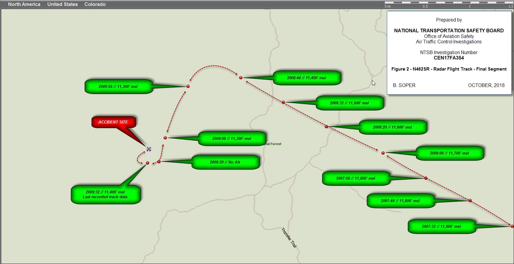
At 8:04 PM, about 10 miles northeast of Glenwood Springs, something changed. The airplane turned northwest, away from the direct course to Moab. It continued northwest for 12 miles at 11,500 feet. At 8:08 PM, a passenger sent a text message: “Taking the long way around, lots of weather, keep you posted.” That would be the last communication from the aircraft.
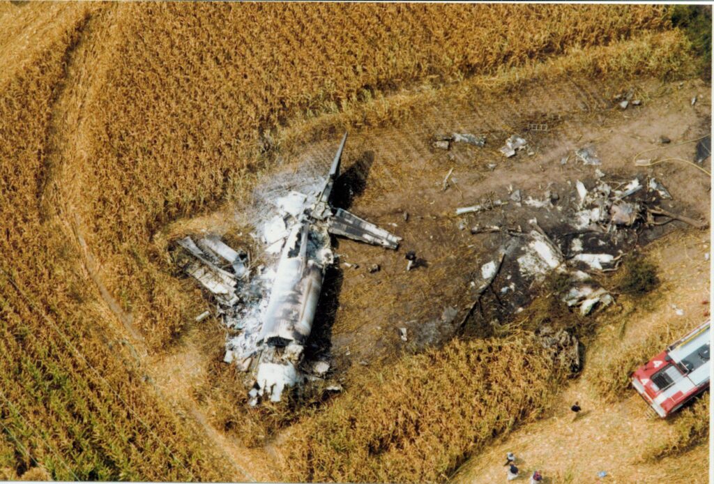
From 8:08 to 8:09 PM, radar showed the airplane in a gradual left turn to the southwest, descending from 11,500 to 11,300 feet, then climbing back to 11,400 feet. The last radar return came at 8:09:32 PM, showing the airplane at 11,400 feet and about a quarter-mile south of where searchers would find the wreckage the next morning. The SR22 had impacted mountainous terrain at 10,800 feet elevation, killing all four occupants.
Investigation Findings
The pilot held a private certificate issued just six months before the accident, in March 2017. His logbook showed 2.4 hours of simulated instrument time. One entry from May 2017 contained his own remarks: “First flight over clouds where I could not see the ground.” He had recently completed a mountain flying course, but critically, he was not instrument rated.
No record existed of the pilot obtaining official weather briefings from Leidos Flight Service or DUATS before departure. While the airplane was equipped with NEXRAD weather radar and ForeFlight, investigators found no archived data showing the pilot accessed weather information, though it’s possible he received updates during flight that left no digital footprint.
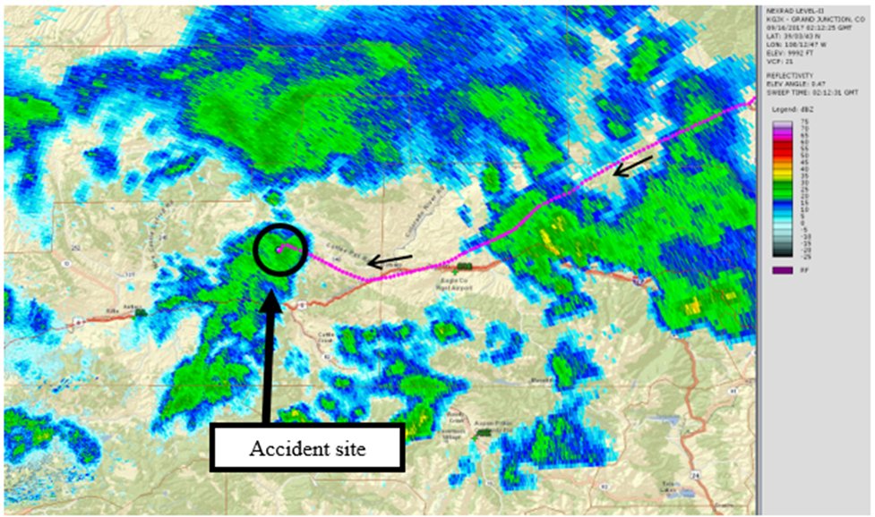
The weather picture that night was ominous. A Convective SIGMET warned of thunderstorms with tops to 35,000 feet moving through the area. An AIRMET forecasted moderate turbulence below 18,000 feet. The area forecast called for broken ceilings at 9,000 feet with isolated thunderstorms. Weather stations near the accident site reported instrument conditions: Sunlight Peak, 16 miles south, was reporting quarter-mile visibility in thunderstorms with 200-foot ceilings. Satellite imagery confirmed cloud cover over the accident site with cloud tops at 22,000 feet.
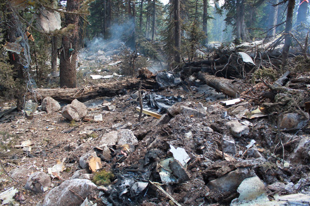
The wreckage examination revealed severe fragmentation consistent with a high-energy impact. The airplane hit trees at about a 34-degree right bank angle before impacting terrain on a 075-degree magnetic heading. The Cirrus Airframe Parachute System had been deployed but never inflated—the rocket was found unexpended, suggesting the system was activated too late or at too low an altitude to be effective. No mechanical anomalies were found that would have prevented normal operation.
NTSB Probable Cause
The non-instrument-rated pilot’s inadequate preflight weather planning, his decision to depart into forecast instrument meteorological conditions along the route of flight, and his continued visual flight into instrument meteorological conditions, which resulted in spatial disorientation and a subsequent loss of airplane control.
Safety Lessons
This accident illustrates three critical decision points where different choices might have prevented tragedy. Each represents a moment where the pilot could have chosen safety over schedule.
- Weather planning is not optional, especially at night over mountains. The pilot’s business delayed his planned 3:30 PM departure to 7:20 PM, pushing the flight into darkness and deteriorating weather. No record exists of him obtaining official weather briefings. When your departure gets delayed into marginal conditions, that’s when you need weather information most, not least.
- That passenger text message was a warning sign, not just an update. “Taking the long way around, lots of weather” described exactly what a VFR pilot should never do at night over mountains. When you’re deviating around weather in mountainous terrain after dark, you’re operating beyond your certificate privileges and safety margins.
- The CAPS system requires altitude and time to work. The parachute was deployed but never inflated, suggesting activation below minimum deployment altitude or insufficient time for the sequence to complete. CAPS is not a substitute for staying out of situations that lead to loss of control—it’s a last resort that needs several thousand feet and specific conditions to save you.
Frequently Asked Questions
Q: Can VFR pilots legally fly at night in mountainous terrain?
A: Yes, but it requires careful planning and weather assessment. Night VFR over mountains eliminates most visual references for terrain avoidance, making weather planning and escape routes critical. Many insurance policies and flight training programs recommend against it without instrument ratings.
Q: Why didn’t the pilot just turn around when encountering weather?
A: Spatial disorientation in IMC can happen quickly to non-instrument pilots. The radar track shows the airplane making altitude changes and turns, suggesting the pilot was trying to navigate around weather, but once in solid IMC, his lack of instrument training likely prevented successful recovery.
Q: How effective is the Cirrus parachute system in situations like this?
A: CAPS has saved many lives, but it requires minimum altitude (typically 500-1000 feet AGL depending on conditions) and time for the sequence to complete. In this case, the system was activated but the parachute never inflated, suggesting activation occurred too late in the emergency sequence.
Q: What weather resources should pilots use for mountain flying?
A: Official weather briefings from Flight Service, DUATS, or ForeFlight’s briefing services provide comprehensive forecasts. For mountain flying, pay special attention to PIREPs, AIRMETs for turbulence and icing, convective SIGMETs, and area forecasts. On-board weather radar like NEXRAD can help but shouldn’t be the primary planning tool.
Q: How can new pilots avoid this type of accident?
A: Establish personal minimums that account for experience level, including restrictions on night mountain flying without instrument ratings. Always obtain official weather briefings. Have concrete go/no-go criteria before departure, and don’t let schedule pressure override safety decisions.