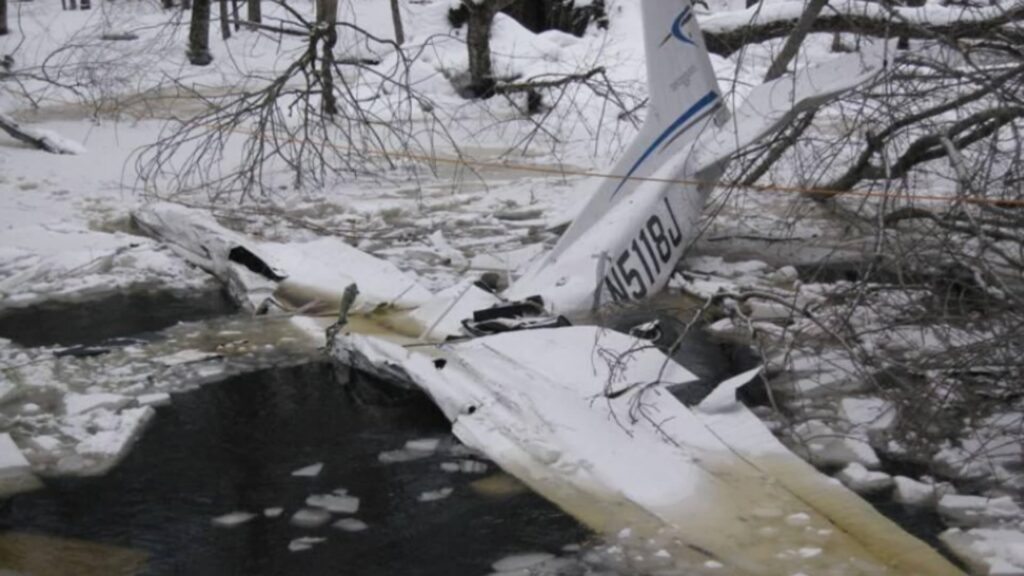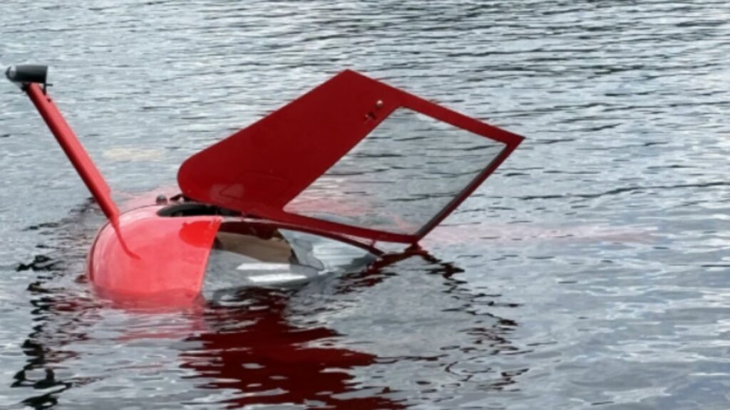


This one involved a classic Alaska trap: a pretty river, a low pass, and a cable you can’t see until it’s too late. On November 10, 2022, a Piper PA-18 Super Cub, N7123K, impacted an unmarked cable while flying low along the Matanuska River near Chickaloon, Alaska. The pilot was part of an informal flight of two with a friend in a Cessna 172. Conditions were daylight VMC, with 10 miles of visibility and an overcast around 8,500 feet. The Super Cub struck the cable about 30 feet above the water, the wings separated, and the airplane came to rest inverted in the river. The pilot did not survive. The NTSB later determined the probable cause to be the pilot’s decision to fly at low altitude, which led to the collision with the cable.
Pilot Background and Experience
The pilot held a student pilot certificate and a current third-class medical. Investigators could not locate the pilot’s logbooks, and the report listed estimated total time as 0 hours because no documentation was available. There were no ratings—no instrument, no commercial, no instructor certificate—just a student certificate. Hours in make and model were unknown for the same reason. As we’ll talk about later, that matters in a low-level river environment where wire awareness and local knowledge make a big difference.
A Simple River Flight Becomes a Tight Environment
The day started out as a straightforward local flight from Wolf Lake Airport (4AK6) in Palmer. The two friends departed around 1100, with the Cessna 172 flying just above and behind the Super Cub. Along the river, the Piper descended and tucked in low, tracking the Matanuska’s flow—exactly the kind of flying that looks benign from the cockpit because the water provides a steady visual reference and it feels “open.” The Cessna pilot watched the PA-18 continue low, then suddenly strike a cable strung across the river. The Super Cub flipped inverted and impacted the water. The cable, as it turned out, was the only way for local residents to access land and houses on the far bank. It had been there since the late 1940s and wasn’t marked.
The Cable You Don’t See—And Maybe Don’t Expect
Let’s talk visibility. River cables are notoriously hard to spot: low contrast, thin profile, and often dark or weathered. This one spanned the river about 30 feet above the surface and had no marker balls or high-visibility sleeves. According to the property owner, it predated most of us—installed in the late 1940s. Critically, the FAA sectional once carried a caution box for the cable, but it was removed in 2019 and then re-added in February 2023, after this accident. That’s a tough detail; if you had looked at a recent chart before 2023, you wouldn’t have seen the caution. The NTSB specifically notes that the cable was unmarked and not new, and that it wasn’t shown in a caution box at the time. A sobering reminder that charts are snapshots, not guarantees.
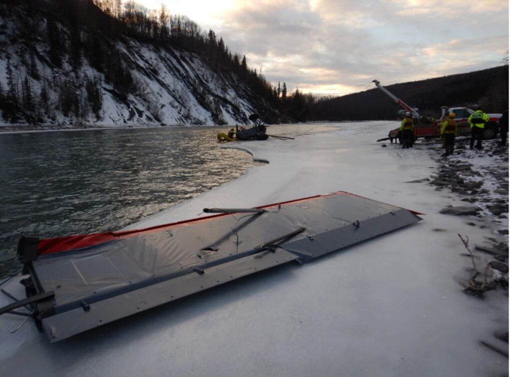
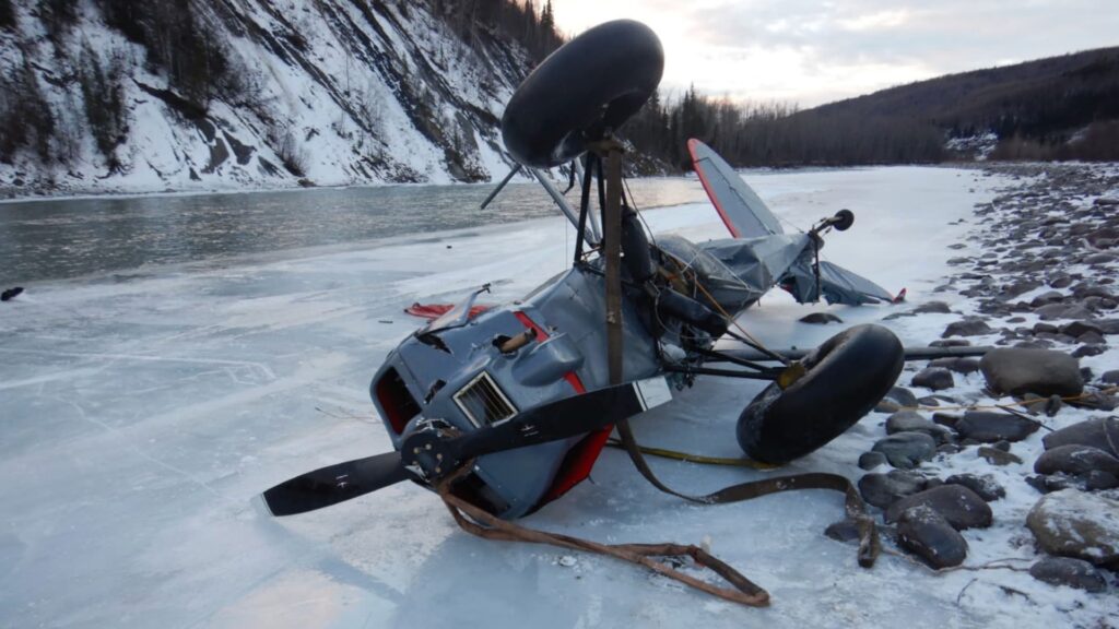
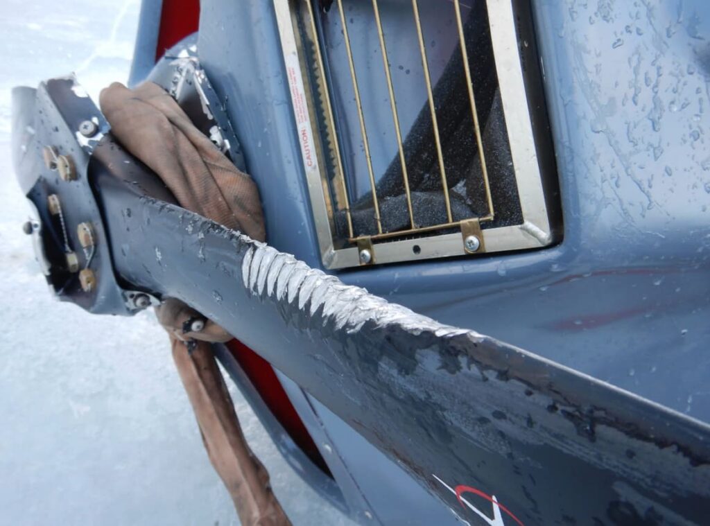
Wreckage Evidence: A Clean Story of a Wire Strike
What investigators found matched what you’d expect from a cable impact. Portions of the cable were wrapped around the right wing. The wings had separated from the fuselage. The propeller blades were still on the crankshaft, with leading-edge gouges consistent with hitting a wire. The windscreen “V-bar” structure was sheared near the lower attachment—the kind of localized, high-energy damage we often see when a tensioned cable slices across the front of the airplane. The engine remained attached, and there was no fire. Nothing in the wreckage suggested a pre-impact engine problem or control failure. The airplane hit a cable at low altitude; the physical evidence lined up cleanly with that scenario.
Weather and Airspace: No Outside Pressure
The weather didn’t force anyone down into the river valley. Visibility was 10 miles with an overcast around 8,500 feet, temperatures just below freezing, and light winds. This was Class G airspace with no flight plan or ATC services. It was a pilot’s choice to fly low along the river, not a weather-driven necessity. That distinction matters when we talk about decision-making: you can always climb when the ceiling allows it, and on this day there was plenty of sky.
Medical and Toxicology Notes
The autopsy identified mild-to-moderate coronary artery disease, but the NTSB concluded it was unlikely to have played a role. Toxicology produced mixed results: one lab detected delta-9-THC in blood, while the FAA’s lab detected only a low level of the non-psychoactive metabolite (carboxy-THC) and no active metabolite. Based on the levels and the circumstances, the Board judged it unlikely that cannabis impaired the decision to fly low or the failure to avoid the cable. Regardless, we all know the FAA’s stance: cannabis is incompatible with flying. The takeaway here isn’t a medical smoking gun—it’s that low-level flight left zero margin for an unexpected obstruction.
Human Factors: Why Low Feels Safer Than It Is
If you’ve ever followed a river in a Super Cub, you know how easy it is to sink into the groove. The ground feels close and slow; your eyeballs tell you you’ve got great control of the picture. Add the Alaska backdrop and you can almost hear the voice in your head: “Just a little lower for a better look.” With two airplanes, there’s also an unspoken formation dynamic: the lead shapes the energy and altitude; the wingman holds a position. In this case, the Cessna flew slightly above and behind and watched the PA-18 go lower. That kind of proximity can create subtle pressure to “keep it smooth” and avoid abrupt corrections—even when a quick climb is the right move. None of that excuses the decision. It explains how an ordinary local flight drifted into a high-risk envelope without any weather, mechanical issues, or operational demands pushing it there.
Wire Threat Management: Practical Steps
This accident slots cleanly into a well-known threat: wires over waterways and valleys. A few habits help:
- Fly high by default in river corridors unless you have a mission that truly requires low-level. If you’re down low for sightseeing, you’re accepting hazards for no operational benefit.
- Prebrief obstructions using multiple sources. Sectionals may show caution boxes, but they can also drop them—as happened here. Cross-check local knowledge, recent NOTAMs, and satellite imagery where practical.
- Treat every river crossing as suspect. Ferries, private tramways, irrigation lines—if there’s development on both banks, assume a cable could be there.
- Maintain an “escape picture.” If you must go low, stay on the side that allows a climbing turn away from terrain and maintain energy so a zoom climb is available.
- In loose two-ship flying, explicitly brief altitudes and “knock-it-off” cues. The wingman should feel free to climb or call “climb now” without social friction.
None of this is exotic. It’s disciplined sightseeing—boring in the best possible way.
The Charting Angle: Don’t Outsource Your Margin
It’s tempting to view the chart removal and later re-addition of the caution box as the headline. It isn’t. The chart didn’t cause the wire to be there or not be there. The cable pre-dated modern charting and, on the day of the accident, the airplane was low enough that even a perfectly marked caution might not have helped much. The right lesson is that charts are aids, not shields. If you’re flying at 30–50 feet AGL over a river, your personal risk decisions—not a magenta box—are doing most of the work. Build margin you don’t have to see to use.
Key Takeaways
This was a capable backcountry airplane on a nice day, flown in a deceptively tight environment. The pilot, a student with undocumented flight time, likely lacked the accumulated “wire sense” that seasoned low-level aviators cultivate—constant suspicion, scanning for poles/anchor points, and a bias to stay higher unless the mission demands low. The wreckage told a straightforward story of a wire strike, and the medical/toxicology findings didn’t change the central lesson. If you’re droning along a river for fun, pull it up a couple hundred feet. If you’re leading a buddy, set an altitude floor and stick to it. If you’re in trail, don’t be shy about climbing or calling “knock it off.” In Alaska—and anywhere with rivers—cables hide in plain sight.
Bottom Line
The Board called it plainly: the pilot’s decision to fly low led to a collision with a cable. That’s the whole chain. Break it at the first link with a higher cruise, a more skeptical eye on waterways, and a standing rule that “pretty” isn’t a reason to be down in the wires.