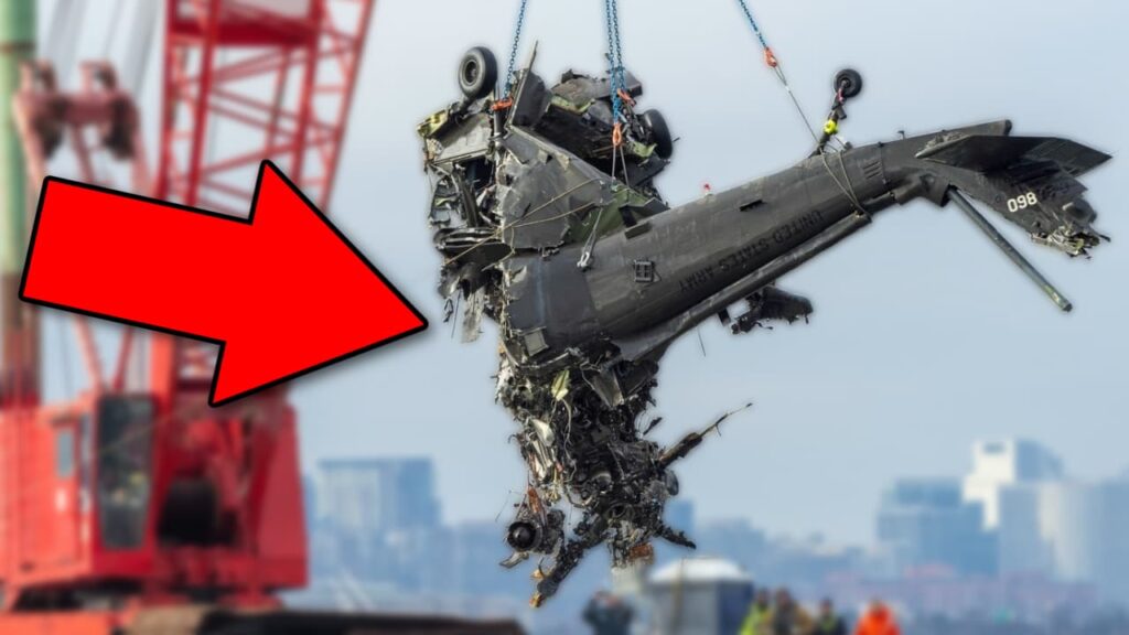
A Night Flight Turns Catastrophic
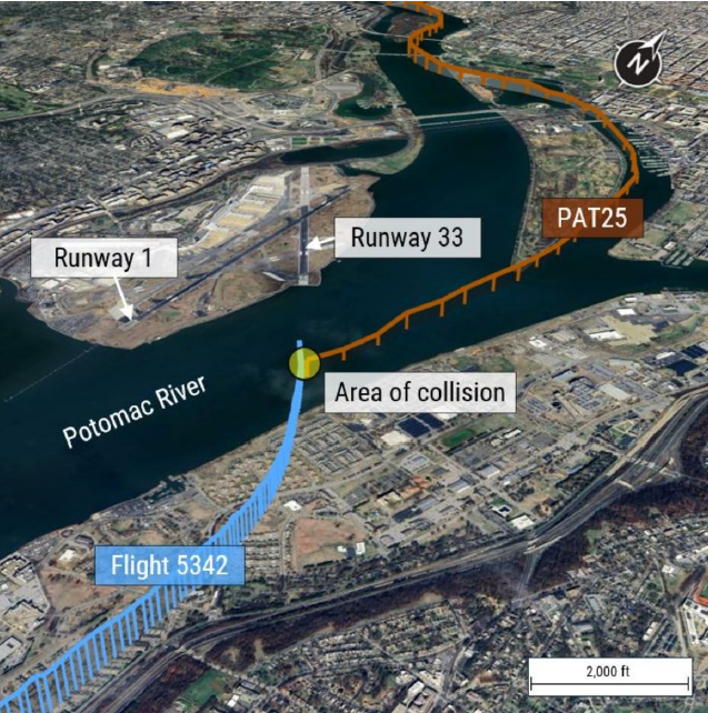
On the night of January 29, 2025, what should have been a routine approach into Ronald Reagan Washington National Airport (DCA) turned into an unimaginable disaster. A U.S. Army Sikorsky UH-60L Blackhawk helicopter—callsign PAT25, collided midair with PSA Airlines CRJ700, operating as Flight 5342, —just half a mile from the airport. Within seconds, both aircraft plunged into the icy Potomac River, claiming the lives of 67 people.
The Flight Crews: Experienced, But Caught in a Fatal Situation
Both aircraft were flown by qualified and experienced pilots:
PSA Airlines Flight 5342 (CRJ700) Crew
- Captain: 3,950 total flight hours, with 3,024 hours in the CRJ700
- First Officer: 2,469 total flight hours, with 966 hours in the CRJ700
- Both pilots held Airline Transport Pilot (ATP) certificates
The captain was the pilot flying, while the first officer was monitoring.
PAT25 (UH-60L Blackhawk) Crew
- Instructor Pilot (IP): 968 total hours, with 300 hours in the UH-60L
- Pilot: 450 total hours, with 326 hours in the UH-60L
- Crew Chief: 1,149 total hours, all in UH-60 helicopters
The Black Hawk crew was conducting a night vision goggle (NVG) standardization evaluation—a routine Army “checkride” for the Pilot. The NTSB didn’t talk about recency of experience for the Blackhawk pilots and whether or not that was a factor in this mishap.
The Timeline: A Chain of Small Errors With Deadly Consequences
8:43 PM – A Last-Minute Runway Change
- Flight 5342 initially received clearance for Runway 1.
- Due to spacing issues with the aircraft in front of and behind them, the tower asked if they could accept Runway 33 instead.
- The crew accepted.
8:46 PM – ATC Warns PAT25 About Traffic
- The controller tells PAT25 that a CRJ is at 1,200 feet, “circling” to Runway 33.
- Key issue: The word “circling” was not captured on the helicopter’s cockpit voice recorder (CVR), meaning they may not have understood the CRJ’s flight path.
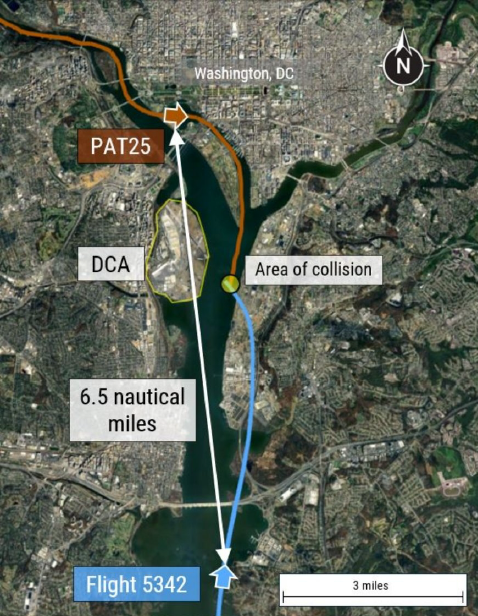
8:46:08 PM – PAT25 Requests “Visual Separation”
- The helicopter crew requests and receives approval to maintain visual separation from the CRJ.
- At this point the helicopter was ~6.5nm away from the the CRJ, making it difficult to positively identify the CRJ
- Issue: PAT25’s view was limited by night vision goggles, which reduce depth perception and peripheral vision.
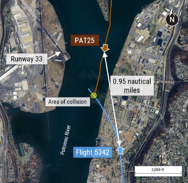
8:47:39 PM – A Last-Minute ATC Directive Gets Missed
- The controller asks PAT25 if they still have the CRJ in sight—a conflict alert is heard in the background.
- 4 seconds later, ATC instructs PAT25 to “pass behind the CRJ.”
- Tragic Miscommunication: A simultaneous radio transmission (mic key press) from PAT25 likely blocked part of the controller’s message. However, the Blackhawk crew reported they had the CRJ in sight.
8:47:59 PM – The Collision
- The CRJ’s left wing strikes the Black Hawk’s tail rotor, severing it instantly.
- The helicopter spins out of control and crashes into the river.
- The CRJ rolls violently, breaking apart before hitting the water.
Helicopter Altitude and Altimeter Discrepancies
- Altitude Discrepancies Between Pilots
- The Instructor Pilot (IP) and the Pilot had conflicting altitude readings.
- At 8:43:48 PM, the pilot stated they were at 300 feet, while the IP indicated 400 feet.
- Shortly after, the IP instructed the pilot to descend to 200 feet, following Helicopter Route 1 altitude restrictions.
- Barometric Altimeter Inconsistencies
- The left-seat pilot’s altimeter set between 29.88 and 29.89 inches of mercury (inHg).
- The right-seat pilot’s altimeter was set to 29.87 inHg.
- These minor differences typically would not result in a 100ft altitude difference between the two altimeters.
- Impact on Situational Awareness
- Small altitude variations (e.g., 200 vs. 300 feet) were not verbally reconciled between the pilots.
Why Did This Happen? The Investigation’s Key Findings
There are multiple safety concerns that made this accident possible.
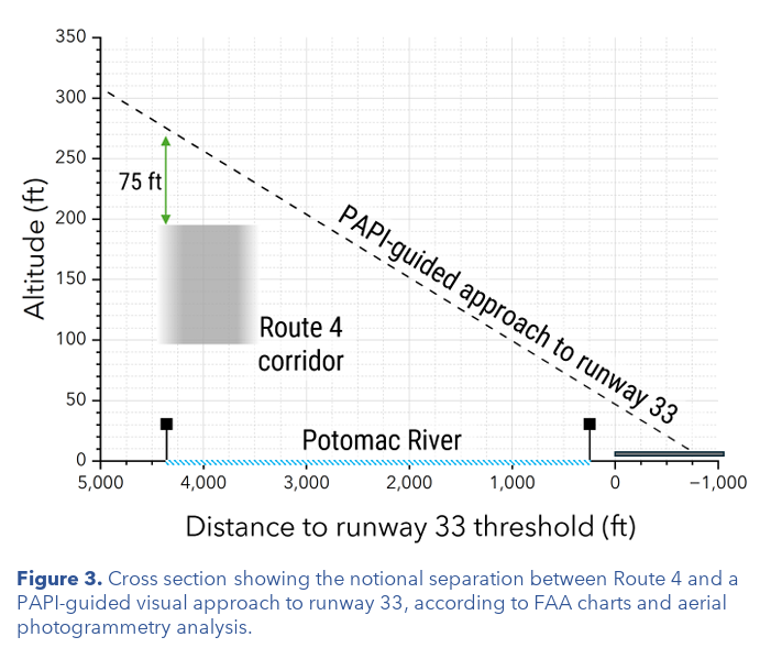
1. Dangerous Overlap Between Helicopter Routes and Commercial Jet Approaches
- Helicopter Route 4 runs directly below the final approach path for Runway 33.
- At just 200 feet altitude, helicopters are dangerously close to arriving jets.
- A review of 2011-2024 flight data showed:
- At least one TCAS resolution advisory (RA) per month due to helicopters.
- In over half of these instances, the helicopter may have been above the route altitude restriction
- Two-thirds of those events occurred at night.
- A review of commercial operations at DCA from Oct 2021 – Dec 2024 revealed:
- 944,179 operations
- 15,214 instances of near-misses between jets and helicopters (less than 1nm lateral and/or less than 400 feet vertical separation
- 85 recorded events where separation was less than 1,500 feet laterally and 200 feet vertically.
2. The Risks of Separate ATC Frequencies for Jets and Helicopters
- Flight 5342 and PAT25 were on different radio frequencies, meaning they couldn’t hear each other’s communications.
- The helicopter crew may not have fully understood the CRJ’s flight path.
3. TCAS Limitations in Urban Airspace
- The CRJ’s TCAS issued a “Traffic” alert, but below 900 feet, TCAS does not issue automatic “Climb” or “Descend” instructions.
- The helicopter had no TCAS display, meaning it relied entirely on visual separation—a serious limitation at night.
4. Human Factors: Night Vision and Workload Management
- Night vision goggles (NVGs) improve visibility but limit peripheral vision.
Immediate Safety Actions Taken
The tragedy prompted immediate FAA and NTSB action:
- January 31, 2025: The FAA banned helicopters from flying over the Potomac River near DCA unless for law enforcement, medical, or presidential missions.
- March 7, 2025: The NTSB issued two urgent safety recommendations:
- Prohibit helicopters from using Route 4 when Runway 33 is active.
- Establish an alternate helicopter route.
These actions aim to permanently separate commercial jet and helicopter traffic.
Final Thoughts: A Tragedy That Must Never Be Repeated
The midair collision over the Potomac was avoidable. A combination of miscommunications, airspace design flaws, and human factors contributed to this disaster but the NTSB is still conducting their investigation to produce a final report and probable cause.