


If you’ve flown at night with weather moving in, you know how quickly a routine training hop can get complicated. This one started as a straightforward night cross-country from Bowling Green to Owensboro—exactly the kind of flight a student needs before the private pilot checkride. But along that black-on-black horizon near Whitesville, Kentucky, a Piper PA-28-161, N3079M, entered convective weather, exceeded its structural limits, and broke up in flight. Both the instructor and student were fatally injured.
Who Was Flying, and What They Brought to the Cockpit
The right seat was occupied by a 22-year-old flight instructor who held commercial and flight instructor certificates with single-engine, multi-engine, and instrument airplane ratings. He had about 447 total hours, including roughly 20 hours at night and 6.6 in actual IMC—numbers that matter in this story. The student in the left seat had about 37 total hours, all in this make and model. It was their first flight together.
The Plan and the Weather Picture
The purpose of the flight was simple: finish off the student’s night requirements. They departed Bowling Green (BWG) around 2155 local, climbed to 4,500 MSL, and proceeded northwest toward Owensboro (OWB) on a VFR flight plan. But the atmosphere didn’t care about their syllabus. A convective SIGMET was active along the route—tops to 42,000 feet, hail up to 1.25 inches, and gusts up to 50 knots. That’s a big, flashing “rethink” sign for any light trainer at night.
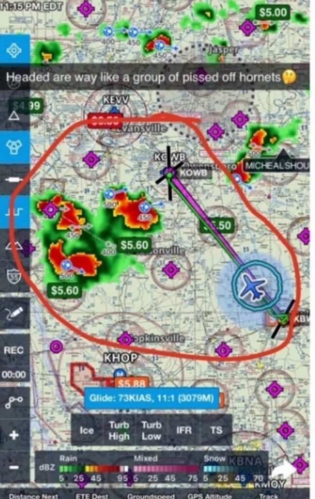
Earlier in the evening, the instructor had obtained a weather briefing from an online commercial source. About 34 minutes before the accident, while enroute, he posted a screen capture to social media showing their position, planned magenta line, and nearby radar returns. Based on their position at the time of that capture, the radar imagery they were looking at was about 10 minutes old. That delay sounds small, but on a night run with rapidly evolving storms, 10 minutes can move the danger right across your nose. The NTSB later emphasized that in-cockpit NEXRAD mosaics always show where weather was, not where it is—and the age indicator doesn’t tell you the age of the oldest pixel in that mosaic. In fast-moving convection, the real delay can be 15–20 minutes.
When the Air Gets Mean
At 2244, the instructor called ATC. The controller advised heavy to extreme precipitation at the airplane’s nine o’clock. That’s an immediate cue to stop going where you’re going and create space. But the airplane continued on a northwesterly course for about two more minutes before the instructor requested an IFR clearance. The controller issued the clearance and assigned a heading of 090° to vector them out of the weather. The instructor reported they were getting “blown around like crazy.” The track showed a turn northwest, then a right circling turn. The controller reiterated 090°. The instructor replied they were in “pretty extreme turbulence.” Moments later, the track tightened into a continuing right descending turn. Radio silence followed. The last ADS-B return was at 2,200 feet, about 1,000 feet northwest of what would be a 25-acre debris field in hilly, wooded terrain.
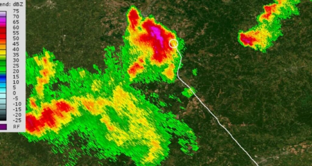
If you look at the NTSB’s figure on page 7, you can see the airplane’s white ground track laid over Louisville’s WSR-88D radar base reflectivity. It paints the picture clearly: the airplane had been threading between evolving cells; the atmosphere was building muscle faster than the cockpit’s information could keep up. On page 4, the social-media screenshot shows the planned route through an area circled in red with embedded returns—the kind of graphic that looks manageable until the line of red re-draws itself where you plan to be.
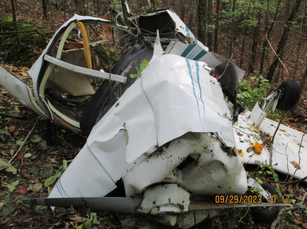
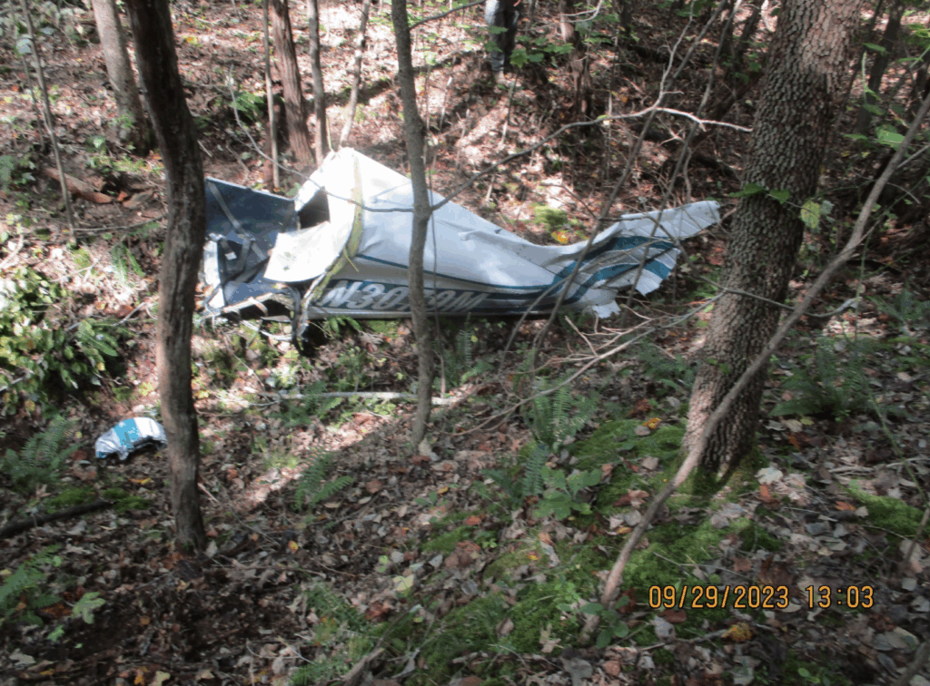
The Breakup and What the Wreckage Said
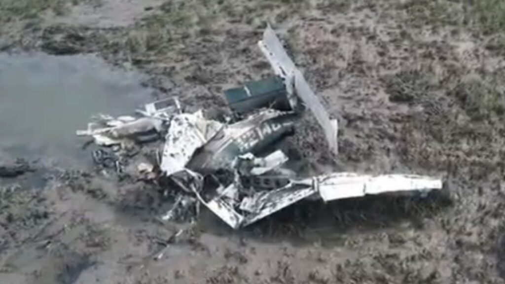
On scene, investigators found a debris field consistent with an in-flight breakup. The fuselage separated aft of the rear seat; the forward fuselage, engine, and right wing came to rest at the western edge of the field. The left wing separated and landed roughly 800 feet east of the nose section. Pieces of the stabilator were scattered even farther—the right side was about 1,500 feet away on the eastern edge. The pattern told a familiar story: structural limits exceeded in severe turbulence or convective activity, followed by aerodynamic and structural overload. The engine showed no pre-impact anomalies; magnetos sparked, cylinders had compression, and fuel consistent with 100LL was found in the system. This wasn’t a powerplant failure. The airframe—overstressed by the air it was in—came apart.
Decision-Making Under a Moving Target
The NTSB’s probable cause was straightforward: the instructor’s improper decision to continue flight into a known area of thunderstorms, culminating in an in-flight breakup. It’s a hard sentence to read because it compresses all the micro-decisions and human factors into one line. But that’s the right lens for safety: you don’t out-climb, out-turn, or out-negotiate convection in a PA-28 at night. You exit early, land short, or hold outside—and you do it with margin.
That brings us to the radar mosaic latency. Many pilots carry an informal rule of thumb that “radar’s about five minutes old.” That’s not how mosaics work. The “age” you see is the age of the composite image assembled by a provider, not the age of the oldest sweep tile in that image. Depending on update cycles, network delays, and where you are relative to individual radar sites, the oldest data in your picture can be 15–20 minutes behind reality. Put another way, your display might be showing where that red cell was when you were still tying down the airplane—meanwhile, the cell has since marched into your flight path. The NTSB’s safety alert in the report spells it out: treat in-cockpit NEXRAD as a strategic tool, not a close-in tactical one, and never use it for thunderstorm penetration.
Training Context Matters
It also mattered that this was a first flight together—new instructor to student. In those first hours, crews are still figuring out how they communicate under pressure. The instructor had solid total time for a brand-new CFI, but limited actual IMC and night experience. None of that is a criticism; it’s a reality of the early professional timeline. The risk picture changes at night in weather, and the margin you need to carry gets wider. A convective SIGMET with embedded storms and gust fronts is a different animal than a scattered deck with rain showers. Align the plan with the résumé, the route, and the time of day.
What We Can All Take Away
A few practical lessons stood out:
- Respect the advisory level. A convective SIGMET isn’t a maybe; it’s a “build a new plan.” Re-route around the whole area, land and wait, or don’t launch. The forecast called for 42,000-foot tops, hail, and 50-knot gusts. Those numbers are telling you the atmosphere is in a mood you can’t fix from the cockpit of a Cherokee.
- Know your sensors. In-cockpit radar mosaics are for the big picture. Use ATC precipitation intensity calls (like “heavy to extreme”) as hard boundaries. When ATC tells you extreme precip is off your wing, it’s time to increase separation immediately, not two minutes later. And if you accept a vector out of weather, commit to it—fly the heading, and verify you’re actually moving away from the returns.
- Night plus convective weather equals higher minimums. In the middle of the day with good visual cues, it’s easier to assess cell movement and get ahead of buildups. At night, you lose that picture. Put a wider ring around anything convective and be quick to divert.
- Training flights are not the place to “thread the needle.” If the goal is a night requirement, there will be other nights. If the goal is experience in weather, pick benign weather and build gradually. Reframing the mission—“Tonight is a weather avoidance exercise with a full-stop at an alternate”—is still training.
Closing the Loop
The wreckage told us what the atmosphere did to N3079M; the timeline told us why the crew ended up there. A night training leg, a convective SIGMET, mosaic radar that lagged the real sky, and a late pivot to IFR all flowed together. The airplane itself didn’t fail; it was flown into air that demanded more structural margin than a PA-28 could give. As pilots, our best move is earlier, wider avoidance and a clear understanding of what our weather tools can’t do. That kind of conservative decision-making doesn’t make for an exciting story in the moment—but it’s exactly how you keep your own story going.
4 Comments
Hello Hoover,your respectfull attitude towards peoples unfortunate tragedy is to be commended.
I can imagine friends and family not being charitable in some of your debriefs.
However the pilots that follow your work all benefit from your dedication.
Thankyou..
This is Junior, isn’t it? His instruction seems about as good as his English “heading are way”. I’m slightly baffled that in the U.S. apparently, a 22 yo with less than 500 hours, 22 at night and 6.6 instrument experience, can teach commercial pilots how to fly 😳. Do they listen?
When these photos of wrecked planes are shown, have they always removed the victims and any blood etc first? I know it’s a strange question.
*sorry, 20 hours at night
(No edit button?)
Seems as if we’ve forgotten to check the HEADWORK box on flight evaluations. Some learned at an early age to listen to that cumulonimbus calling ” come to me little airplane and I’ll crush you.” Being smart is a requirement, acting smart is not.