The Morning Flight That Never Reached the Coast
On the quiet morning of June 17, 2023, a seasoned pilot and his passenger set out from Ebensburg Airport (9G8) in rural Pennsylvania. Their destination was Ocean City, Maryland—a flight that should have been routine. Yet, less than 10 minutes after departure, their Piper PA-30 Twin Comanche was reduced to fragments in a wooded area just two miles south of the runway.
The pilot, a 54-year-old commercial certificate holder with single- and multi-engine land ratings and an instrument rating, had accumulated 1,284 total flight hours, including recent experience: 26 hours in the last 90 days and 15 in the last 30 days. However, crucially, he hadn’t logged any actual instrument time in the eight months prior to the flight—a detail that would prove significant.
A Departure Into Darkness
At 5:06 a.m., before civil twilight and well before sunrise, the Twin Comanche lifted off from runway 25 under an instrument flight rules (IFR) plan. Almost immediately, the challenges mounted. The weather near Ebensburg that morning was poor: overcast skies at 200 feet, visibility as low as half a mile, and fog reported by nearby Johnstown Airport and a local landowner. The small, non-towered airfield offered no weather reporting or IFR departures off runway 25, adding complexity.
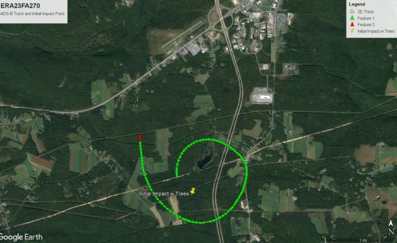
ADS-B data and airport surveillance video traced the plane as it climbed to about 1,500 feet above ground level, entering a continuous left turn that eventually circled 360 degrees. Tragically, the plane then descended steeply into trees and terrain at a 55-degree bank and a 30-degree descent angle—hallmarks of spatial disorientation and loss of control.
A High-Energy Impact with No Mechanical Cause
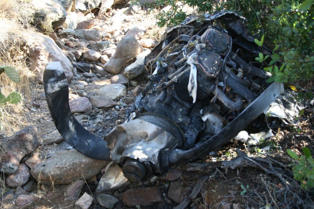
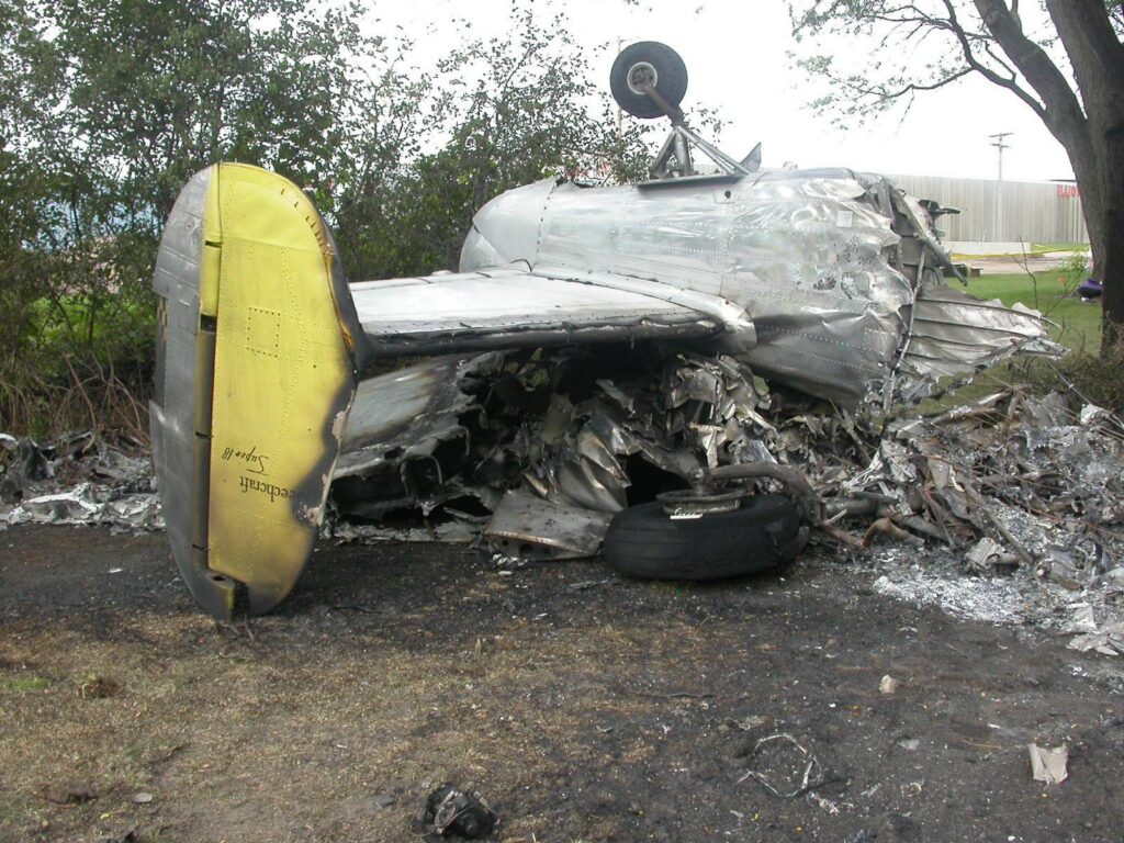
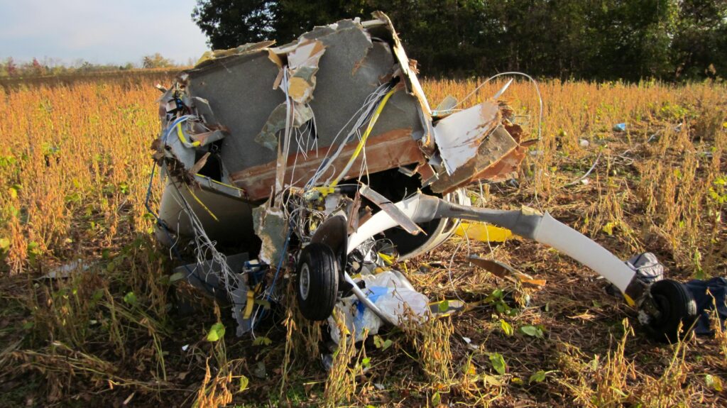
When NTSB investigators combed through the wreckage, they found no evidence of preexisting mechanical failure. Both engines were producing power at impact, the control surfaces showed signs of overload failure consistent with the crash sequence, and the propellers bore the telltale scars of rotation under power.
The wreckage path—375 feet long and 120 feet wide—spoke to the severity of the impact. Both wings, the empennage, and the fuselage were fragmented. Some components, like engine parts and control cables, were destroyed or deformed beyond testability. A post-impact fire consumed portions of the structure.
Spatial Disorientation: A Hidden Enemy
So what went wrong? The NTSB pointed to spatial disorientation—a pilot’s loss of awareness of their aircraft’s position relative to the Earth—as the probable cause. The dark, fog-shrouded conditions deprived the pilot of external visual cues. With no actual instrument time logged in months, his ability to rely solely on instruments may have been diminished.
The FAA’s Airplane Flying Handbook and Introduction to Aviation Physiology both highlight how easily the inner ear can trick a pilot flying blind. Minor or prolonged attitude changes often go undetected, or worse, the pilot feels movement that isn’t occurring. The result can be the unwitting entry into a bank or dive, as appeared to happen here.
Weather Briefings and Preparedness
A striking detail of this tragedy is that the pilot didn’t obtain a formal weather briefing from flight service, nor did he review weather imagery in ForeFlight, despite filing his IFR plan through the app. Whether he underestimated the conditions or simply missed a key update, it meant taking off into IMC with incomplete situational awareness.
Compounding this, the departure runway lacked published weather minimums, and the airport didn’t have an IFR approach or departure procedure for that direction. The pilot was flying into a low ceiling and near-zero visibility without the structure and safeguards of a controlled field or well-documented departure.
Lessons in Risk Management
This accident underscores several critical lessons for pilots:
✅ Respect for Current Proficiency — The pilot’s instrument rating and previous practice didn’t offset eight months without actual IMC flying. Currency isn’t just about regulatory minimums; it’s about capability and confidence.
✅ Preflight Weather Planning — Thorough briefings and weather reviews aren’t just a formality; they’re essential for informed go/no-go decisions, especially before a flight into IMC from a non-towered field.
✅ Hazards of Night IMC Departures — Combining darkness with poor weather elevates risk. When external visual cues vanish, even experienced pilots can fall victim to the tricks of the vestibular system.
✅ Departure Procedures Matter — Choosing an airport or runway with a published procedure—or delaying until conditions improve—can provide vital structure during critical phases of flight.
A Somber Reminder
This accident highlights how insidious spatial disorientation can be, and how preparation, proficiency, and conservative decision-making are our best defenses. The NTSB’s findings don’t assign fault, but they do offer insights that can help all aviators avoid similar tragedies.